Carrières-sur-Seine night lights from space
Night Light of Carrières-sur-Seine (Île-de-France) from space (France) Src. Average luminocity for 10x10km area is 96.5923% and for 50x50km: 66.8557%.
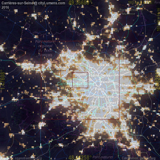
Analysis of Carrières-sur-Seine night lights 2016
Square area 10x10 km:
 58.52%
90-99
30.68%80-89
4.26%70-79
4.83%60-69
0.57%50-59
0.57%40-49
0.57%30-39
0%20-29
0%10-19
0%0-9
0%Square area 50x50 km:
30.83%90-99
15.53%80-89
4.91%70-79
4.5%60-69
5.14%50-59
4.38%40-49
5.53%30-39
4.99%20-29
7.35%10-19
10.52%0-9
6.32%Clear (daylight) street map image can be seen on geolist.org.
Map coordinates:
49° 22' 0.8" North, 1° 28' 33.9" East
48° 54' 24.7" North, 2° 10' 45.1" East
48° 26' 33.3" North, 2° 52' 56.4" East
Some cities around Carrières-sur-Seine sort by population:
• Nanterre
2.6 km =1.6 mi,  129°
129°
• Rueil-Malmaison
3.5 km =2.2 mi,  167°
167°
• Houilles
1.9 km =1.2 mi,  30°
30°
• Chatou
2.4 km =1.5 mi,  218°
218°
• Bezons
3.1 km =1.9 mi,  51°
51°
• Le Vésinet
3.7 km =2.3 mi,  245°
245°
• Montesson
3.1 km =1.9 mi,  274°
274°
• Croissy-sur-Seine
4.3 km =2.7 mi, 224°
3028520 (p: 12,829)
Sources (retrieved 2019-11-25):
» Earth at Night: Flat Maps 2012, 2016