Balma night lights from space
Night Light of Balma (Occitanie) from space (France) Src. Average luminocity for 10x10km area is 78.2364% and for 50x50km: 25.2328%.
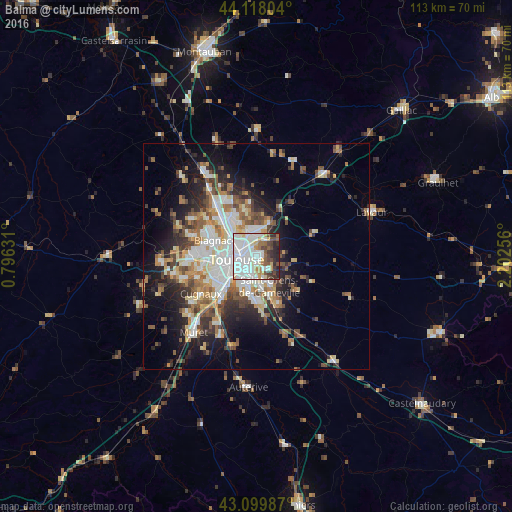
Analysis of Balma night lights 2016
Square area 10x10 km:
 35%
35%90-99
21.67%80-89
6.97%70-79
3.03%60-69
4.24%50-59
6.06%40-49
8.48%30-39
5.91%20-29
8.33%10-19
0.3%0-9
0%Square area 50x50 km:
5.06%90-99
5.33%80-89
2.81%70-79
2.52%60-69
3.28%50-59
3.38%40-49
3.7%30-39
3.3%20-29
5.65%10-19
9.59%0-9
55.35%Clear (daylight) street map image can be seen on geolist.org.
Map coordinates:
44° 7' 4.9" North, 0° 47' 46.7" East
43° 36' 40" North, 1° 29' 58" East
43° 5' 59.5" North, 2° 12' 9.2" East
Some cities around Balma sort by population:
• Toulouse
4.6 km =2.9 mi,  260°
260°
• Blagnac
8.8 km =5.5 mi,  285°
285°
• Saint-Orens-de-Gameville
6.9 km =4.3 mi,  156°
156°
• Ramonville-Saint-Agne
7.5 km =4.7 mi,  195°
195°
• L'Union
5.6 km =3.5 mi,  346°
346°
• Saint-Jean
5.9 km =3.7 mi,  359°
359°
• Aucamville
8.7 km =5.4 mi,  318°
318°
• Launaguet
8.2 km =5.1 mi,  334°
334°
3035204 (p: 15,553)
Sources (retrieved 2019-11-25):
» Earth at Night: Flat Maps 2012, 2016