Saint-Orens-de-Gameville night lights from space
Night Light of Saint-Orens-de-Gameville (Occitanie) from space (France) Src. Average luminocity for 10x10km area is 63.5683% and for 50x50km: 24.5878%.
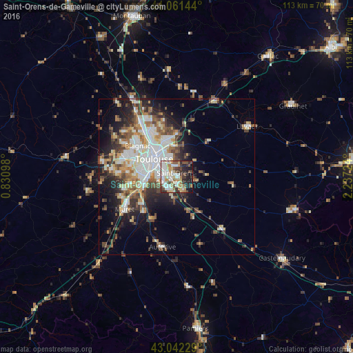
Analysis of Saint-Orens-de-Gameville night lights 2016
Square area 10x10 km:
 15.56%
90-99
18.57%80-89
7.78%70-79
5.24%60-69
8.57%50-59
5.4%40-49
8.89%30-39
8.73%20-29
9.84%10-19
11.27%0-9
0.16%Square area 50x50 km:
5.05%90-99
5.32%80-89
2.72%70-79
2.5%60-69
3.11%50-59
3.27%40-49
3.71%30-39
3.25%20-29
5.57%10-19
8.34%0-9
57.15%Clear (daylight) street map image can be seen on geolist.org.
Map coordinates:
44° 3' 41.2" North, 0° 49' 51.5" East
43° 33' 14.5" North, 1° 32' 2.8" East
43° 2' 32.2" North, 2° 14' 14.1" East
Some cities around Saint-Orens-de-Gameville sort by population:
• Toulouse
9.2 km =5.7 mi,  307°
307°
• Blagnac
14.3 km =8.9 mi, 307°
• Balma
6.9 km =4.3 mi,  336°
336°
• Ramonville-Saint-Agne
4.8 km =3 mi,  259°
259°
• L'Union
12.5 km =7.8 mi, 340°
• Castanet-Tolosan
5.1 km =3.2 mi,  214°
214°
• Portet-sur-Garonne
10.8 km =6.7 mi,  251°
251°
• Escalquens
4.5 km =2.8 mi,  153°
153°
2977832 (p: 12,576)
Sources (retrieved 2019-11-25):
» Earth at Night: Flat Maps 2012, 2016