Saint-André-lez-Lille night lights from space
Night Light of Saint-André-lez-Lille (Hauts-de-France) from space (France) Src. Average luminocity for 10x10km area is 87.1698% and for 50x50km: 47.5313%.
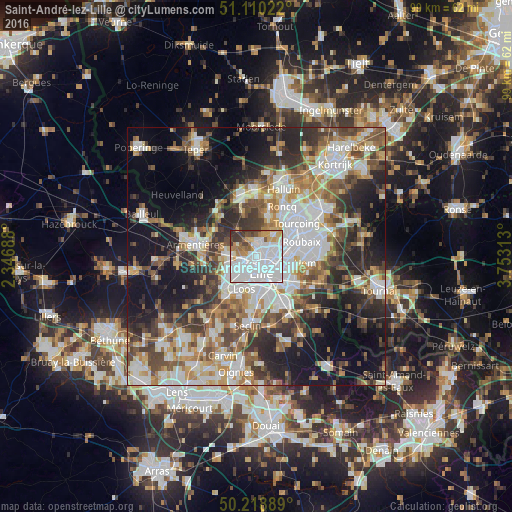
Analysis of Saint-André-lez-Lille night lights 2016
Square area 10x10 km:
 52.41%
90-99
17.38%80-89
3.74%70-79
7.49%60-69
4.55%50-59
3.88%40-49
3.48%30-39
5.88%20-29
1.2%10-19
0%0-9
0%Square area 50x50 km:
11.63%90-99
9.4%80-89
4.18%70-79
5.86%60-69
6.23%50-59
6.8%40-49
7.22%30-39
7.04%20-29
10.45%10-19
16.68%0-9
14.52%Clear (daylight) street map image can be seen on geolist.org.
Map coordinates:
51° 6' 36.8" North, 2° 20' 48.8" East
50° 40' 0" North, 3° 3' 0" East
50° 13' 8" North, 3° 45' 11.3" East
Some cities around Saint-André-lez-Lille sort by population:
• Lille
3.8 km =2.4 mi,  170°
170°
• Marcq-en-Barœul
2.3 km =1.4 mi,  90°
90°
• Lomme
5.1 km =3.2 mi,  239°
239°
• Lambersart
2.2 km =1.4 mi,  212°
212°
• La Madeleine
2.9 km =1.8 mi,  141°
141°
• Bondues
5 km =3.1 mi,  38°
38°
• Marquette-lez-Lille
1.6 km =1 mi,  46°
46°
• Wambrechies
1.8 km =1.1 mi,  355°
355°
2981779 (p: 10,931)
Sources (retrieved 2019-11-25):
» Earth at Night: Flat Maps 2012, 2016