Wittenheim night lights from space
Night Light of Wittenheim (Grand Est) from space (France) Src. Average luminocity for 10x10km area is 59.3705% and for 50x50km: 18.1646%.
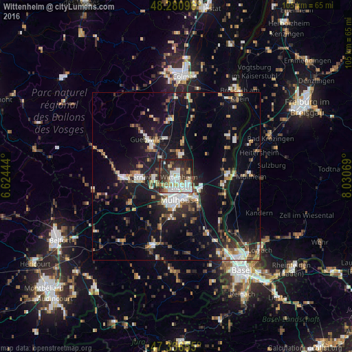
Analysis of Wittenheim night lights 2016
Square area 10x10 km:
 18.15%
90-99
14.88%80-89
4.91%70-79
5.51%60-69
3.87%50-59
3.13%40-49
6.25%30-39
14.29%20-29
20.83%10-19
8.04%0-9
0.15%Square area 50x50 km:
2.92%90-99
2.84%80-89
1.25%70-79
2.12%60-69
1.84%50-59
2.29%40-49
2.38%30-39
3.03%20-29
4.9%10-19
15.67%0-9
60.76%Clear (daylight) street map image can be seen on geolist.org.
Map coordinates:
48° 16' 51.5" North, 6° 37' 28" East
47° 48' 39.2" North, 7° 19' 39.2" East
47° 20' 11.6" North, 8° 1' 50.5" East
Some cities around Wittenheim sort by population:
• Mulhouse
6.5 km =4 mi,  179°
179°
• Illzach
4.5 km =2.8 mi,  156°
156°
• Riedisheim
7.5 km =4.7 mi, 156°
• Kingersheim
2.2 km =1.4 mi, 182°
• Pfastatt
5 km =3.1 mi,  201°
201°
• Ensisheim
6.3 km =3.9 mi,  15°
15°
• Lutterbach
6.7 km =4.2 mi,  211°
211°
• Sausheim
4.3 km =2.7 mi,  128°
128°
2967318 (p: 15,747)
Sources (retrieved 2019-11-25):
» Earth at Night: Flat Maps 2012, 2016