Gonesse night lights from space
Night Light of Gonesse (Île-de-France) from space (France) Src. Average luminocity for 10x10km area is 85.3705% and for 50x50km: 60.5182%.
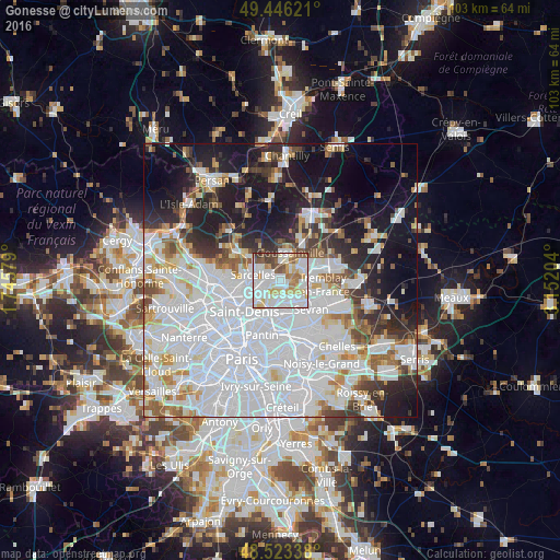

Analysis of Gonesse night lights 2016
Square area 10x10 km:
 32.14%
90-99
28.27%80-89
9.52%70-79
8.04%60-69
6.4%50-59
7.59%40-49
5.06%30-39
2.98%20-29
0%10-19
0%0-9
0%Square area 50x50 km:
29.15%90-99
13.42%80-89
4.06%70-79
3.53%60-69
4.2%50-59
3.81%40-49
3.52%30-39
4.46%20-29
7.23%10-19
14.87%0-9
11.76%Clear (daylight) street map image can be seen on geolist.org.
Map coordinates:
49° 26' 46.4" North, 1° 44' 44.8" East
48° 59' 12.9" North, 2° 26' 56.1" East
48° 31' 24.2" North, 3° 9' 7.3" East
Some cities around Gonesse sort by population:
• Sarcelles
5.3 km =3.3 mi,  282°
282°
• Le Blanc-Mesnil
5.4 km =3.4 mi,  170°
170°
• Garges-lès-Gonesse
4.3 km =2.7 mi,  240°
240°
• Goussainville
3.2 km =2 mi,  22°
22°
• Villiers-le-Bel
4.4 km =2.7 mi,  303°
303°
• Arnouville
2.4 km =1.5 mi,  260°
260°
• Le Bourget
6 km =3.7 mi,  189°
189°
• Dugny
4.4 km =2.7 mi,  211°
211°
3015689 (p: 26,758)
Sources (retrieved 2019-11-25):
» Earth at Night: Flat Maps 2012, 2016