Waziers night lights from space
Night Light of Waziers (Hauts-de-France) from space (France) Src. Average luminocity for 10x10km area is 78.7815% and for 50x50km: 39.9911%.
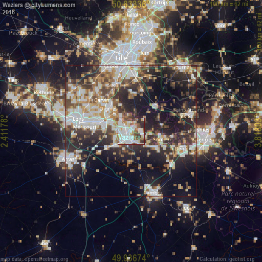
Analysis of Waziers night lights 2016
Square area 10x10 km:
 26.47%
90-99
28.57%80-89
5.6%70-79
3.78%60-69
8.4%50-59
8.96%40-49
7.42%30-39
5.74%20-29
5.04%10-19
0%0-9
0%Square area 50x50 km:
7.87%90-99
8.94%80-89
3.48%70-79
3.91%60-69
5.4%50-59
4.78%40-49
5.87%30-39
7.04%20-29
12.79%10-19
18.25%0-9
21.69%Clear (daylight) street map image can be seen on geolist.org.
Map coordinates:
50° 50' 0.1" North, 2° 24' 42.4" East
50° 23' 13.8" North, 3° 6' 53.6" East
49° 56' 12.3" North, 3° 49' 4.9" East
Some cities around Waziers sort by population:
• Douai
3.1 km =1.9 mi,  234°
234°
• Sin-le-Noble
3.1 km =1.9 mi,  157°
157°
• Auby
5.3 km =3.3 mi,  305°
305°
• Cuincy
4.5 km =2.8 mi,  258°
258°
• Lallaing
3.9 km =2.4 mi,  85°
85°
• Roost-Warendin
3.6 km =2.2 mi,  347°
347°
• Flers-en-Escrebieux
4 km =2.5 mi,  287°
287°
• Dechy
4.1 km =2.5 mi,  178°
178°
2967410 (p: 7,852)
Sources (retrieved 2019-11-25):
» Earth at Night: Flat Maps 2012, 2016