Ernée night lights from space
Night Light of Ernée (Pays de la Loire) from space (France) Src. Average luminocity for 10x10km area is 3.1012% and for 50x50km: 3.3577%.
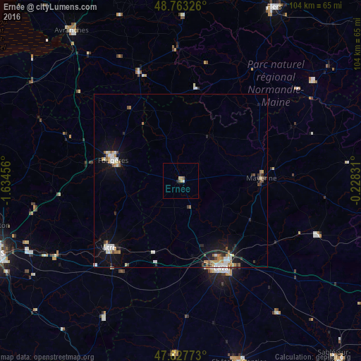
Analysis of Ernée night lights 2016
Square area 10x10 km:
 0.3%
0.3%90-99
0.3%80-89
0%70-79
1.79%60-69
0%50-59
0.6%40-49
0.6%30-39
0%20-29
0.6%10-19
0%0-9
95.83%Square area 50x50 km:
0.5%90-99
0.62%80-89
0.31%70-79
0.44%60-69
0.52%50-59
0.29%40-49
0.26%30-39
0.33%20-29
0.67%10-19
2.2%0-9
93.86%Clear (daylight) street map image can be seen on geolist.org.
Map coordinates:
48° 45' 47.7" North, 1° 38' 4.4" West
48° 17' 51.5" North, 0° 55' 53.1" West
47° 49' 39.8" North, 0° 13' 41.9" West
Some cities around Ernée sort by population:
• Laval
27.9 km =17.3 mi,  153°
153°
• Fougères
20.7 km =12.9 mi,  286°
286°
• Vitré
28.5 km =17.7 mi,  225°
225°
• Mayenne
23.5 km =14.6 mi,  88°
88°
• Saint-Berthevin
26.7 km =16.6 mi,  164°
164°
• Châteaubourg
40.5 km =25.2 mi,  239°
239°
• Changé
24.3 km =15.1 mi, 155°
• Bonchamp-lès-Laval
30.2 km =18.8 mi, 145°
3019895 (p: 6,127)
Sources (retrieved 2019-11-25):
» Earth at Night: Flat Maps 2012, 2016