Bonchamp-lès-Laval night lights from space
Night Light of Bonchamp-lès-Laval (Pays de la Loire) from space (France) Src. Average luminocity for 10x10km area is 22.4446% and for 50x50km: 2.8163%.
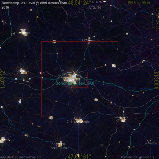
Analysis of Bonchamp-lès-Laval night lights 2016
Square area 10x10 km:
 4.55%
4.55%90-99
4.83%80-89
1.7%70-79
3.13%60-69
3.41%50-59
0.99%40-49
0.99%30-39
3.55%20-29
5.97%10-19
18.18%0-9
52.7%Square area 50x50 km:
0.45%90-99
0.49%80-89
0.21%70-79
0.39%60-69
0.39%50-59
0.17%40-49
0.27%30-39
0.37%20-29
0.83%10-19
2.01%0-9
94.42%Clear (daylight) street map image can be seen on geolist.org.
Map coordinates:
48° 32' 28.5" North, 1° 24' 11.2" West
48° 4' 24.9" North, 0° 42' 0" West
47° 36' 5.8" North, 0° 0' 11.3" East
Some cities around Bonchamp-lès-Laval sort by population:
• Laval
4.7 km =2.9 mi,  269°
269°
• Mayenne
26.3 km =16.3 mi,  14°
14°
• Château-Gontier
27.2 km =16.9 mi,  180°
180°
• Évron
24.1 km =15 mi,  67°
67°
• Saint-Berthevin
9.9 km =6.2 mi, 265°
• Ernée
30.2 km =18.8 mi,  325°
325°
• Changé
7.5 km =4.7 mi,  292°
292°
• Craon
31.3 km =19.4 mi,  216°
216°
3031835 (p: 5,094)
Sources (retrieved 2019-11-25):
» Earth at Night: Flat Maps 2012, 2016