Châteaubourg night lights from space
Night Light of Châteaubourg (Brittany) from space (France) Src. Average luminocity for 10x10km area is 4.9256% and for 50x50km: 5.9277%.
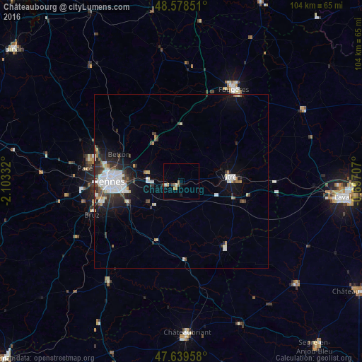
Analysis of Châteaubourg night lights 2016
Square area 10x10 km:
 0%
0%90-99
1.04%80-89
0.15%70-79
2.08%60-69
0.6%50-59
0.6%40-49
0.6%30-39
0.6%20-29
0%10-19
1.19%0-9
93.15%Square area 50x50 km:
1.67%90-99
1.09%80-89
0.35%70-79
0.47%60-69
0.23%50-59
0.47%40-49
0.82%30-39
0.96%20-29
1.63%10-19
3.02%0-9
89.29%Clear (daylight) street map image can be seen on geolist.org.
Map coordinates:
48° 34' 42.6" North, 2° 6' 12" West
48° 6' 40.3" North, 1° 24' 0.7" West
47° 38' 22.5" North, 0° 41' 49.5" West
Some cities around Châteaubourg sort by population:
• Vitré
14.5 km =9 mi,  87°
87°
• Cesson-Sévigné
15.1 km =9.4 mi,  274°
274°
• Vern-sur-Seiche
16.6 km =10.3 mi,  243°
243°
• Chantepie
16.2 km =10.1 mi,  261°
261°
• Liffré
13.9 km =8.6 mi,  324°
324°
• Fouillard
14.3 km =8.9 mi,  291°
291°
• Janzé
18.4 km =11.4 mi,  203°
203°
• Acigné
10.5 km =6.5 mi,  283°
283°
3026306 (p: 5,362)
Sources (retrieved 2019-11-25):
» Earth at Night: Flat Maps 2012, 2016