Carbon-Blanc night lights from space
Night Light of Carbon-Blanc (Nouvelle-Aquitaine) from space (France) Src. Average luminocity for 10x10km area is 76.8317% and for 50x50km: 28.2846%.
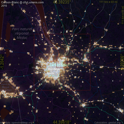
Analysis of Carbon-Blanc night lights 2016
Square area 10x10 km:
 24.92%
90-99
24.29%80-89
7.14%70-79
5.87%60-69
10.16%50-59
6.35%40-49
7.3%30-39
10.48%20-29
3.49%10-19
0%0-9
0%Square area 50x50 km:
6.06%90-99
5.02%80-89
2.81%70-79
2.8%60-69
3.84%50-59
3.46%40-49
3.99%30-39
4.05%20-29
6.79%10-19
16.55%0-9
44.63%Clear (daylight) street map image can be seen on geolist.org.
Map coordinates:
45° 23' 32.5" North, 1° 12' 15.1" West
44° 53' 47.1" North, 0° 30' 3.9" West
44° 23' 46.2" North, 0° 12' 7.4" East
Some cities around Carbon-Blanc sort by population:
• Le Bouscat
8.1 km =5 mi,  245°
245°
• Lormont
2.7 km =1.7 mi,  208°
208°
• Cenon
4.7 km =2.9 mi,  196°
196°
• Floirac
7.2 km =4.5 mi,  188°
188°
• Ambarès-et-Lagrave
2.6 km =1.6 mi,  31°
31°
• Saint-Loubès
6.2 km =3.9 mi,  70°
70°
• Bassens
1.4 km =0.9 mi,  298°
298°
• Artigues-près-Bordeaux
5.3 km =3.3 mi, 193°
3028653 (p: 6,760)
Sources (retrieved 2019-11-25):
» Earth at Night: Flat Maps 2012, 2016