Osny night lights from space
Night Light of Osny (Île-de-France) from space (France) Src. Average luminocity for 10x10km area is 60.9717% and for 50x50km: 39.2841%.
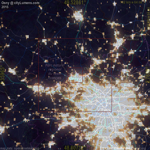
Analysis of Osny night lights 2016
Square area 10x10 km:
 19.64%
90-99
19.35%80-89
3.72%70-79
6.7%60-69
4.76%50-59
2.23%40-49
3.72%30-39
6.99%20-29
14.88%10-19
16.82%0-9
1.19%Square area 50x50 km:
14.54%90-99
8.06%80-89
3.09%70-79
3.31%60-69
3.44%50-59
3.44%40-49
4.22%30-39
3.48%20-29
7.69%10-19
12.81%0-9
35.92%Clear (daylight) street map image can be seen on geolist.org.
Map coordinates:
49° 31' 43" North, 1° 21' 34.7" East
49° 4' 12.4" North, 2° 3' 46" East
48° 36' 26.4" North, 2° 45' 57.2" East
Some cities around Osny sort by population:
• Cergy-Pontoise
3.6 km =2.2 mi,  162°
162°
• Cergy
3.9 km =2.4 mi,  165°
165°
• Pontoise
3.5 km =2.2 mi,  129°
129°
• Saint-Ouen-l’Aumône
5.2 km =3.2 mi,  124°
124°
• Vauréal
4.6 km =2.9 mi,  207°
207°
• Jouy-le-Moutier
6.8 km =4.2 mi,  193°
193°
• Éragny
6.5 km =4 mi, 155°
• Courdimanche
6 km =3.7 mi,  229°
229°
2989130 (p: 16,545)
Sources (retrieved 2019-11-25):
» Earth at Night: Flat Maps 2012, 2016