Cosne-Cours-sur-Loire night lights from space
Night Light of Cosne-Cours-sur-Loire (Bourgogne-Franche-Comté) from space (France) Src. Average luminocity for 10x10km area is 2.6719% and for 50x50km: 0.7261%.
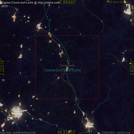
Analysis of Cosne-Cours-sur-Loire night lights 2016
Square area 10x10 km:
 0%
0%90-99
0%80-89
0%70-79
0%60-69
1.14%50-59
0%40-49
2.41%30-39
0.99%20-29
0.57%10-19
0.57%0-9
94.32%Square area 50x50 km:
0.01%90-99
0.01%80-89
0.07%70-79
0.14%60-69
0.19%50-59
0.06%40-49
0.27%30-39
0.13%20-29
0.29%10-19
0.12%0-9
98.7%Clear (daylight) street map image can be seen on geolist.org.
Map coordinates:
47° 53' 4.9" North, 2° 13' 19.8" East
47° 24' 39.6" North, 2° 55' 31" East
46° 55' 58.9" North, 3° 37' 42.3" East
Some cities around Cosne-Cours-sur-Loire sort by population:
• Bourges
53.8 km =33.4 mi,  227°
227°
• Nevers
50.1 km =31.1 mi,  159°
159°
• Gien
38.4 km =23.9 mi,  324°
324°
• Varennes-Vauzelles
46.7 km =29 mi, 159°
• Briare
28.2 km =17.5 mi,  331°
331°
• Aubigny-sur-Nère
37.6 km =23.4 mi,  283°
283°
• La Charité-sur-Loire
26.2 km =16.3 mi, 164°
• Saint-Germain-du-Puy
48 km =29.8 mi,  223°
223°
3023476 (p: 11,613)
Sources (retrieved 2019-11-25):
» Earth at Night: Flat Maps 2012, 2016