Chantonnay night lights from space
Night Light of Chantonnay (Pays de la Loire) from space (France) Src. Average luminocity for 10x10km area is 3.2443% and for 50x50km: 2.4521%.
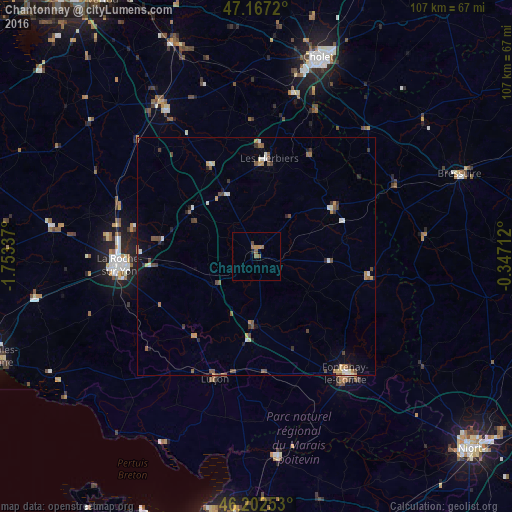
Analysis of Chantonnay night lights 2016
Square area 10x10 km:
 0%
0%90-99
0%80-89
0%70-79
0.99%60-69
1.28%50-59
1.7%40-49
0.57%30-39
0%20-29
0%10-19
0.57%0-9
94.89%Square area 50x50 km:
0.18%90-99
0.35%80-89
0.19%70-79
0.32%60-69
0.33%50-59
0.57%40-49
0.62%30-39
0.33%20-29
0.27%10-19
0.69%0-9
96.16%Clear (daylight) street map image can be seen on geolist.org.
Map coordinates:
47° 10' 1.9" North, 1° 45' 12.1" West
46° 41' 13.3" North, 1° 3' 0.9" West
46° 12' 9.1" North, 0° 20' 49.6" West
Some cities around Chantonnay sort by population:
• La Roche-sur-Yon
29.3 km =18.2 mi,  265°
265°
• Fontenay-le-Comte
30.7 km =19.1 mi,  142°
142°
• Les Herbiers
20.1 km =12.5 mi,  7°
7°
• Luçon
27 km =16.8 mi,  199°
199°
• Mortagne-sur-Sèvre
34.8 km =21.6 mi, 12°
• Le Poiré-sur-Vie
36.2 km =22.5 mi,  284°
284°
• Pouzauges
19.3 km =12 mi,  57°
57°
• Montaigu
37.7 km =23.4 mi,  328°
328°
3026823 (p: 8,375)
Sources (retrieved 2019-11-25):
» Earth at Night: Flat Maps 2012, 2016