Les Herbiers night lights from space
Night Light of Les Herbiers (Pays de la Loire) from space (France) Src. Average luminocity for 10x10km area is 8.1979% and for 50x50km: 4.5019%.
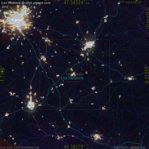
Analysis of Les Herbiers night lights 2016
Square area 10x10 km:
 1.04%
1.04%90-99
1.34%80-89
0.74%70-79
1.19%60-69
0.89%50-59
2.53%40-49
0.6%30-39
1.04%20-29
0.15%10-19
0.15%0-9
90.33%Square area 50x50 km:
0.7%90-99
0.83%80-89
0.3%70-79
0.3%60-69
0.42%50-59
0.74%40-49
0.98%30-39
0.6%20-29
1.17%10-19
2%0-9
91.96%Clear (daylight) street map image can be seen on geolist.org.
Map coordinates:
47° 20' 42.9" North, 1° 43' 11.3" West
46° 52' 0" North, 1° 1' 0" West
46° 23' 1.6" North, 0° 18' 48.8" West
Some cities around Les Herbiers sort by population:
• Cholet
23.8 km =14.8 mi,  25°
25°
• Chantonnay
20.1 km =12.5 mi,  187°
187°
• Clisson
31.8 km =19.8 mi,  320°
320°
• Mortagne-sur-Sèvre
14.9 km =9.3 mi,  20°
20°
• Saint-Macaire-en-Mauges
28.6 km =17.8 mi,  3°
3°
• Pouzauges
16.8 km =10.4 mi,  125°
125°
• Nueil-les-Aubiers
33.7 km =20.9 mi,  77°
77°
• Montaigu
25.3 km =15.7 mi,  298°
298°
3000648 (p: 15,664)
Sources (retrieved 2019-11-25):
» Earth at Night: Flat Maps 2012, 2016