Champagne-au-Mont-d’Or night lights from space
Night Light of Champagne-au-Mont-d’Or (Auvergne-Rhône-Alpes) from space (France) Src. Average luminocity for 10x10km area is 78.2247% and for 50x50km: 33.2027%.
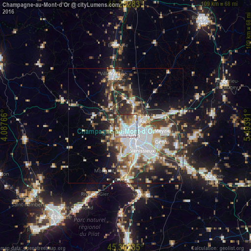
Analysis of Champagne-au-Mont-d’Or night lights 2016
Square area 10x10 km:
 33.93%
90-99
18.9%80-89
4.46%70-79
5.95%60-69
8.33%50-59
12.35%40-49
5.06%30-39
7.59%20-29
3.42%10-19
0%0-9
0%Square area 50x50 km:
8.6%90-99
6.94%80-89
2.51%70-79
3.44%60-69
3.67%50-59
4.28%40-49
4.65%30-39
5.62%20-29
9.48%10-19
10.08%0-9
40.71%Clear (daylight) street map image can be seen on geolist.org.
Map coordinates:
46° 16' 58.2" North, 4° 5' 15.6" East
45° 47' 41.1" North, 4° 47' 26.8" East
45° 18' 8.5" North, 5° 29' 38.1" East
Some cities around Champagne-au-Mont-d’Or sort by population:
• Lyon
6.7 km =4.2 mi,  139°
139°
• Caluire-et-Cuire
4.3 km =2.7 mi,  90°
90°
• Sainte-Foy-lès-Lyon
6.8 km =4.2 mi,  172°
172°
• Écully
2.5 km =1.6 mi,  204°
204°
• Tassin-la-Demi-Lune
4.4 km =2.7 mi,  182°
182°
• Dardilly
3.2 km =2 mi,  292°
292°
• Fontaines-sur-Saône
6.2 km =3.9 mi,  42°
42°
• Saint-Genis-les-Ollières
6.5 km =4 mi,  230°
230°
3027255 (p: 5,681)
Sources (retrieved 2019-11-25):
» Earth at Night: Flat Maps 2012, 2016