Dardilly night lights from space
Night Light of Dardilly (Auvergne-Rhône-Alpes) from space (France) Src. Average luminocity for 10x10km area is 62.058% and for 50x50km: 31.7462%.
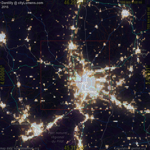
Analysis of Dardilly night lights 2016
Square area 10x10 km:
 15.77%
90-99
12.95%80-89
3.57%70-79
5.36%60-69
10.12%50-59
14.73%40-49
9.23%30-39
12.35%20-29
15.77%10-19
0.15%0-9
0%Square area 50x50 km:
8.35%90-99
6.66%80-89
2.48%70-79
3.27%60-69
3.47%50-59
4.09%40-49
4.58%30-39
5.25%20-29
8.14%10-19
9.27%0-9
44.43%Clear (daylight) street map image can be seen on geolist.org.
Map coordinates:
46° 17' 36.9" North, 4° 3' 0.2" East
45° 48' 20.1" North, 4° 45' 11.5" East
45° 18' 47.8" North, 5° 27' 22.7" East
Some cities around Dardilly sort by population:
• Caluire-et-Cuire
7.3 km =4.5 mi,  99°
99°
• Écully
4 km =2.5 mi,  151°
151°
• Tassin-la-Demi-Lune
6.2 km =3.9 mi, 154°
• Francheville
7.7 km =4.8 mi,  174°
174°
• Craponne
7.1 km =4.4 mi,  199°
199°
• Champagne-au-Mont-d’Or
3.2 km =2 mi,  112°
112°
• Lentilly
7.1 km =4.4 mi,  281°
281°
• Saint-Genis-les-Ollières
5.8 km =3.6 mi, 201°
3021729 (p: 8,612)
Sources (retrieved 2019-11-25):
» Earth at Night: Flat Maps 2012, 2016