Saint-Genis-les-Ollières night lights from space
Night Light of Saint-Genis-les-Ollières (Auvergne-Rhône-Alpes) from space (France) Src. Average luminocity for 10x10km area is 63.2508% and for 50x50km: 31.0288%.
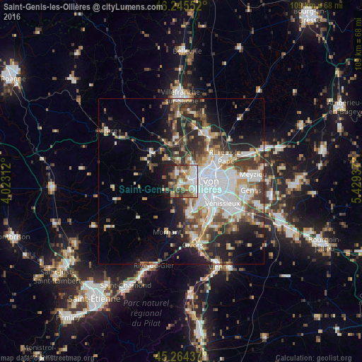
Analysis of Saint-Genis-les-Ollières night lights 2016
Square area 10x10 km:
 14.29%
90-99
16.67%80-89
4.29%70-79
6.35%60-69
11.9%50-59
13.65%40-49
9.52%30-39
6.19%20-29
7.14%10-19
9.84%0-9
0.16%Square area 50x50 km:
8.05%90-99
6.38%80-89
2.46%70-79
3.14%60-69
3.49%50-59
4.04%40-49
4.32%30-39
4.95%20-29
7.88%10-19
9.96%0-9
45.33%Clear (daylight) street map image can be seen on geolist.org.
Map coordinates:
46° 14' 43.9" North, 4° 1' 23.2" East
45° 45' 25.6" North, 4° 43' 34.5" East
45° 15' 51.7" North, 5° 25' 45.7" East
Some cities around Saint-Genis-les-Ollières sort by population:
• Écully
4.4 km =2.7 mi,  64°
64°
• Tassin-la-Demi-Lune
4.8 km =3 mi,  92°
92°
• Francheville
3.7 km =2.3 mi,  128°
128°
• Dardilly
5.8 km =3.6 mi,  21°
21°
• Craponne
1.3 km =0.8 mi,  190°
190°
• Chaponost
5.4 km =3.4 mi,  166°
166°
• La Mulatière
7.4 km =4.6 mi,  115°
115°
• Champagne-au-Mont-d’Or
6.5 km =4 mi,  50°
50°
2979984 (p: 5,029)
Sources (retrieved 2019-11-25):
» Earth at Night: Flat Maps 2012, 2016