Tassin-la-Demi-Lune night lights from space
Night Light of Tassin-la-Demi-Lune (Auvergne-Rhône-Alpes) from space (France) Src. Average luminocity for 10x10km area is 88.1984% and for 50x50km: 33.2604%.
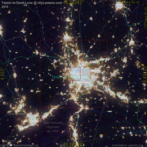
Analysis of Tassin-la-Demi-Lune night lights 2016
Square area 10x10 km:
 50.48%
90-99
21.27%80-89
2.7%70-79
4.44%60-69
7.62%50-59
8.1%40-49
3.33%30-39
1.9%20-29
0.16%10-19
0%0-9
0%Square area 50x50 km:
8.41%90-99
6.72%80-89
2.54%70-79
3.45%60-69
3.68%50-59
4.3%40-49
4.7%30-39
5.74%20-29
9.76%10-19
11.15%0-9
39.55%Clear (daylight) street map image can be seen on geolist.org.
Map coordinates:
46° 14' 36.3" North, 4° 5' 6" East
45° 45' 18" North, 4° 47' 17.2" East
45° 15' 44.1" North, 5° 29' 28.5" East
Some cities around Tassin-la-Demi-Lune sort by population:
• Lyon
4.6 km =2.9 mi,  99°
99°
• Oullins
4.8 km =3 mi,  161°
161°
• Sainte-Foy-lès-Lyon
2.6 km =1.6 mi,  154°
154°
• Écully
2.3 km =1.4 mi,  339°
339°
• Francheville
2.8 km =1.7 mi,  222°
222°
• La Mulatière
3.5 km =2.2 mi, 147°
• Champagne-au-Mont-d’Or
4.4 km =2.7 mi,  2°
2°
• Saint-Genis-les-Ollières
4.8 km =3 mi,  272°
272°
2973317 (p: 16,920)
Sources (retrieved 2019-11-25):
» Earth at Night: Flat Maps 2012, 2016