Brie-Comte-Robert night lights from space
Night Light of Brie-Comte-Robert (Île-de-France) from space (France) Src. Average luminocity for 10x10km area is 51.9018% and for 50x50km: 49.528%.
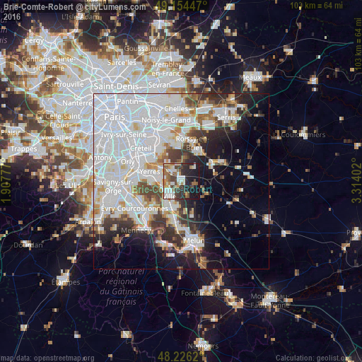
Analysis of Brie-Comte-Robert night lights 2016
Square area 10x10 km:
 9.82%
9.82%90-99
13.84%80-89
4.02%70-79
2.83%60-69
9.38%50-59
6.1%40-49
10.57%30-39
8.18%20-29
14.43%10-19
19.64%0-9
1.19%Square area 50x50 km:
23.01%90-99
11.24%80-89
2.91%70-79
3.18%60-69
3.45%50-59
2.93%40-49
3.71%30-39
4.81%20-29
6.18%10-19
8.7%0-9
29.88%Clear (daylight) street map image can be seen on geolist.org.
Map coordinates:
49° 9' 16.1" North, 1° 54' 28" East
48° 41' 32.9" North, 2° 36' 39.2" East
48° 13' 34.3" North, 3° 18' 50.5" East
Some cities around Brie-Comte-Robert sort by population:
• Combs-la-Ville
4.3 km =2.7 mi,  224°
224°
• Moissy-Cramayel
7.4 km =4.6 mi,  185°
185°
• Épinay-sous-Sénart
7.3 km =4.5 mi,  267°
267°
• Villecresnes
6.1 km =3.8 mi,  300°
300°
• Lésigny
5.7 km =3.5 mi,  3°
3°
• Quincy-sous-Sénart
6 km =3.7 mi,  248°
248°
• Lieusaint
7.9 km =4.9 mi, 215°
• Boussy-Saint-Antoine
5.9 km =3.7 mi, 268°
3030101 (p: 15,892)
Sources (retrieved 2019-11-25):
» Earth at Night: Flat Maps 2012, 2016