Lésigny night lights from space
Night Light of Lésigny (Île-de-France) from space (France) Src. Average luminocity for 10x10km area is 52.3304% and for 50x50km: 55.5707%.
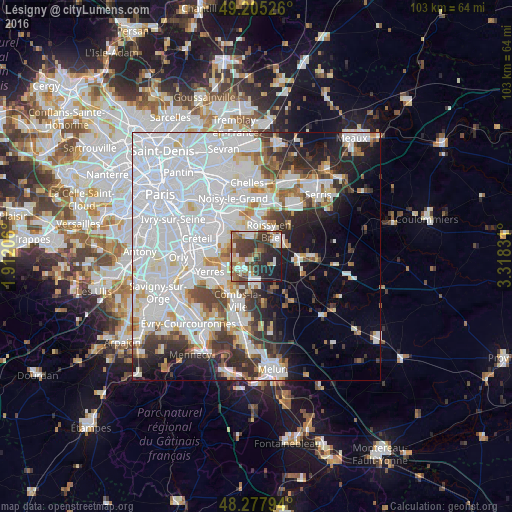
Analysis of Lésigny night lights 2016
Square area 10x10 km:
 7.74%
7.74%90-99
12.35%80-89
3.72%70-79
4.17%60-69
8.18%50-59
7.59%40-49
14.29%30-39
16.07%20-29
15.18%10-19
10.71%0-9
0%Square area 50x50 km:
27.13%90-99
12.59%80-89
3.22%70-79
3.31%60-69
3.58%50-59
3.05%40-49
3.86%30-39
5.06%20-29
6.26%10-19
8.62%0-9
23.32%Clear (daylight) street map image can be seen on geolist.org.
Map coordinates:
49° 12' 18.9" North, 1° 54' 43.4" East
48° 44' 37.5" North, 2° 36' 54.6" East
48° 16' 40.6" North, 3° 19' 5.9" East
Some cities around Lésigny sort by population:
• Pontault-Combault
6.1 km =3.8 mi,  354°
354°
• Sucy-en-Brie
6.5 km =4 mi,  295°
295°
• Ozoir-la-Ferrière
4.7 km =2.9 mi,  56°
56°
• Roissy-en-Brie
5.8 km =3.6 mi,  23°
23°
• Brie-Comte-Robert
5.7 km =3.5 mi,  183°
183°
• La Queue-en-Brie
5.2 km =3.2 mi,  331°
331°
• Ormesson-sur-Marne
7 km =4.3 mi,  312°
312°
• Villecresnes
6.2 km =3.9 mi,  244°
244°
3000602 (p: 8,421)
Sources (retrieved 2019-11-25):
» Earth at Night: Flat Maps 2012, 2016