Bonneuil-sur-Marne night lights from space
Night Light of Bonneuil-sur-Marne (Île-de-France) from space (France) Src. Average luminocity for 10x10km area is 95.6122% and for 50x50km: 69.5759%.
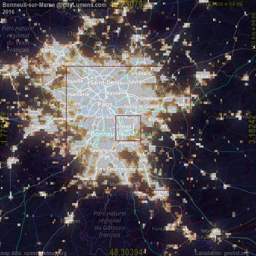
Analysis of Bonneuil-sur-Marne night lights 2016
Square area 10x10 km:
 72.16%
90-99
13.07%80-89
1.99%70-79
8.95%60-69
2.56%50-59
1.28%40-49
0%30-39
0%20-29
0%10-19
0%0-9
0%Square area 50x50 km:
33.89%90-99
17.18%80-89
4.38%70-79
4.64%60-69
4.84%50-59
3.82%40-49
4.49%30-39
4.92%20-29
6.33%10-19
6.78%0-9
8.73%Clear (daylight) street map image can be seen on geolist.org.
Map coordinates:
49° 13' 50.8" North, 1° 46' 34.2" East
48° 46' 10.2" North, 2° 28' 45.5" East
48° 18' 14.2" North, 3° 10' 56.7" East
Some cities around Bonneuil-sur-Marne sort by population:
• Créteil
2.8 km =1.7 mi,  338°
338°
• Saint-Maur-des-Fossés
2.9 km =1.8 mi,  20°
20°
• Choisy-le-Roi
4.4 km =2.7 mi,  268°
268°
• Villeneuve-Saint-Georges
4.7 km =2.9 mi,  207°
207°
• Sucy-en-Brie
4.1 km =2.5 mi,  91°
91°
• Limeil-Brévannes
2.8 km =1.7 mi,  168°
168°
• Boissy-Saint-Léger
3.1 km =1.9 mi,  130°
130°
• Valenton
2.9 km =1.8 mi,  201°
201°
3031709 (p: 18,723)
Sources (retrieved 2019-11-25):
» Earth at Night: Flat Maps 2012, 2016