Bischwiller night lights from space
Night Light of Bischwiller (Grand Est) from space (France) Src. Average luminocity for 10x10km area is 30.3594% and for 50x50km: 18.7016%.
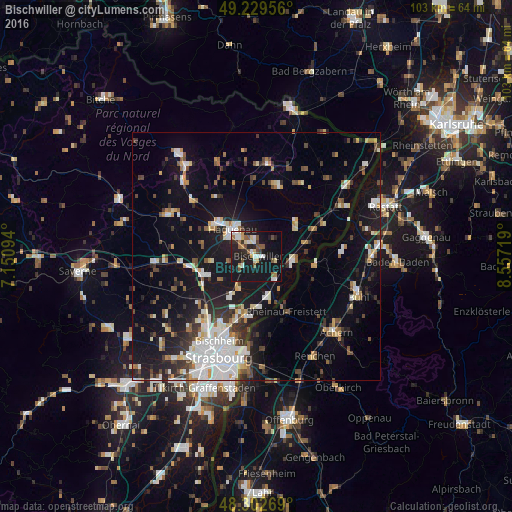
Analysis of Bischwiller night lights 2016
Square area 10x10 km:
 4.55%
4.55%90-99
5.54%80-89
3.13%70-79
1.99%60-69
3.41%50-59
4.97%40-49
3.41%30-39
1.28%20-29
8.81%10-19
47.87%0-9
15.06%Square area 50x50 km:
3.73%90-99
3.43%80-89
1.46%70-79
1.54%60-69
1.5%50-59
1.94%40-49
2.51%30-39
2.47%20-29
3.82%10-19
15.74%0-9
61.85%Clear (daylight) street map image can be seen on geolist.org.
Map coordinates:
49° 13' 46.4" North, 7° 9' 3.4" East
48° 46' 5.7" North, 7° 51' 14.6" East
48° 18' 9.7" North, 8° 33' 25.9" East
Some cities around Bischwiller sort by population:
• Haguenau
7 km =4.3 mi,  318°
318°
• Rheinau, DE
12.9 km =8 mi,  151°
151°
• Brumath
11.2 km =7 mi,  250°
250°
• Souffelweyersheim
16.9 km =10.5 mi,  209°
209°
• La Wantzenau
12.4 km =7.7 mi,  187°
187°
• Vendenheim
15.3 km =9.5 mi,  223°
223°
• Reichstett
15.2 km =9.4 mi, 208°
• Lichtenau, DE
12 km =7.5 mi,  112°
112°
3032544 (p: 12,308)
Sources (retrieved 2019-11-25):
» Earth at Night: Flat Maps 2012, 2016