Reichstett night lights from space
Night Light of Reichstett (Grand Est) from space (France) Src. Average luminocity for 10x10km area is 61.5208% and for 50x50km: 23.0205%.
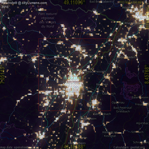
Analysis of Reichstett night lights 2016
Square area 10x10 km:
 16.37%
90-99
18.9%80-89
7.29%70-79
3.27%60-69
4.17%50-59
5.06%40-49
4.02%30-39
15.77%20-29
19.05%10-19
6.1%0-9
0%Square area 50x50 km:
4.79%90-99
4.45%80-89
1.88%70-79
1.81%60-69
2.04%50-59
2.15%40-49
2.32%30-39
3.37%20-29
6.23%10-19
20.77%0-9
50.19%Clear (daylight) street map image can be seen on geolist.org.
Map coordinates:
49° 6' 39.5" North, 7° 3' 5.1" East
48° 38' 54.8" North, 7° 45' 16.4" East
48° 10' 54.8" North, 8° 27' 27.6" East
Some cities around Reichstett sort by population:
• Strasbourg
7.2 km =4.5 mi,  185°
185°
• Schiltigheim
4.6 km =2.9 mi,  184°
184°
• Bischheim
3.6 km =2.2 mi, 181°
• Hœnheim
2.9 km =1.8 mi, 178°
• Souffelweyersheim
1.8 km =1.1 mi,  213°
213°
• La Wantzenau
5.7 km =3.5 mi,  79°
79°
• Vendenheim
4 km =2.5 mi,  305°
305°
• Mundolsheim
3.1 km =1.9 mi,  256°
256°
2984135 (p: 5,135)
Sources (retrieved 2019-11-25):
» Earth at Night: Flat Maps 2012, 2016