Lichtenau night lights from space
Night Light of Lichtenau (Baden-Württemberg) from space (Germany) Src. Average luminocity for 10x10km area is 6.9643% and for 50x50km: 19.6005%.
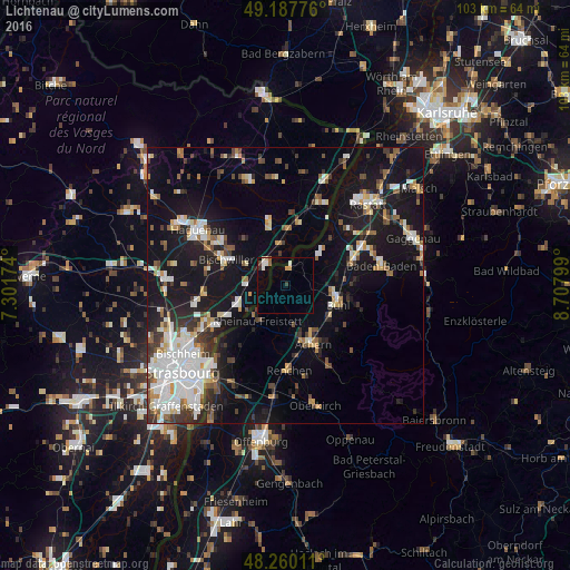
Analysis of Lichtenau night lights 2016
Square area 10x10 km:
 1.49%
1.49%90-99
0.89%80-89
0.89%70-79
0.89%60-69
0.3%50-59
0.6%40-49
0.6%30-39
0.6%20-29
0.6%10-19
0%0-9
93.15%Square area 50x50 km:
4.11%90-99
3.7%80-89
1.59%70-79
1.71%60-69
1.61%50-59
2.21%40-49
2.05%30-39
2.74%20-29
3.58%10-19
18.25%0-9
58.46%Clear (daylight) street map image can be seen on geolist.org.
Map coordinates:
49° 11' 15.9" North, 7° 18' 6.3" East
48° 43' 33.9" North, 8° 0' 17.5" East
48° 15' 36.4" North, 8° 42' 28.8" East
Some cities around Lichtenau sort by population:
• Bühl
10.1 km =6.3 mi,  108°
108°
• Achern
11.8 km =7.3 mi,  153°
153°
• Bischwiller, FR
12 km =7.5 mi,  292°
292°
• Sinzheim
12.7 km =7.9 mi,  69°
69°
• Rheinau
8.3 km =5.2 mi,  216°
216°
• Zell
5.7 km =3.5 mi,  131°
131°
• Ottersweier
10.1 km =6.3 mi, 127°
• Sasbach
11.6 km =7.2 mi, 145°
2878140 (p: 5,023)
Sources (retrieved 2019-11-25):
» Earth at Night: Flat Maps 2012, 2016