Rheinau night lights from space
Night Light of Rheinau (Baden-Württemberg) from space (Germany) Src. Average luminocity for 10x10km area is 8.1205% and for 50x50km: 21.3313%.
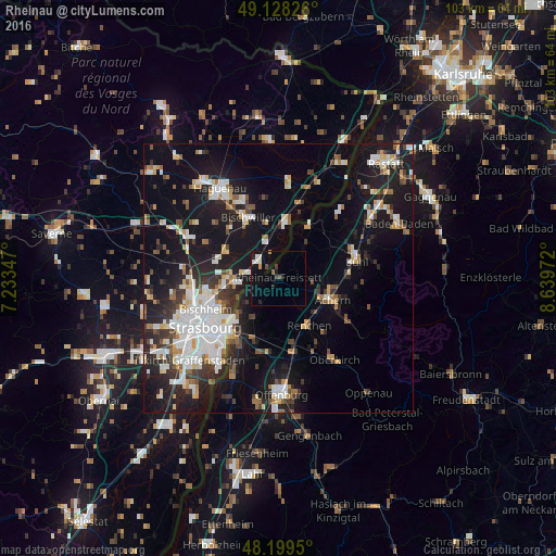
Analysis of Rheinau night lights 2016
Square area 10x10 km:
 1.04%
1.04%90-99
1.49%80-89
0.45%70-79
0.89%60-69
0.6%50-59
0.6%40-49
0.89%30-39
0.89%20-29
1.19%10-19
5.95%0-9
86.01%Square area 50x50 km:
4.56%90-99
3.99%80-89
1.85%70-79
1.84%60-69
1.8%50-59
2.03%40-49
2.06%30-39
3.12%20-29
5.29%10-19
19.16%0-9
54.29%Clear (daylight) street map image can be seen on geolist.org.
Map coordinates:
49° 7' 41.7" North, 7° 14' 0.5" East
48° 39' 57.7" North, 7° 56' 11.7" East
48° 11' 58.2" North, 8° 38' 23" East
Some cities around Rheinau sort by population:
• Achern
11 km =6.8 mi,  110°
110°
• Bischwiller, FR
12.9 km =8 mi,  331°
331°
• Zell
9.7 km =6 mi,  72°
72°
• Renchen
10.3 km =6.4 mi,  146°
146°
• Ottersweier
13 km =8.1 mi,  87°
87°
• La Wantzenau, FR
7.8 km =4.8 mi,  263°
263°
• Sasbach
11.9 km =7.4 mi,  104°
104°
• Lichtenau
8.3 km =5.2 mi,  36°
36°
3209262 (p: 10,997)
Sources (retrieved 2019-11-25):
» Earth at Night: Flat Maps 2012, 2016