Brumath night lights from space
Night Light of Brumath (Grand Est) from space (France) Src. Average luminocity for 10x10km area is 23.9836% and for 50x50km: 20.574%.
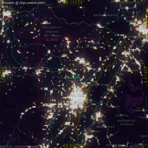
Analysis of Brumath night lights 2016
Square area 10x10 km:
 2.83%
2.83%90-99
4.17%80-89
1.19%70-79
2.08%60-69
1.93%50-59
4.02%40-49
1.04%30-39
1.19%20-29
1.49%10-19
70.09%0-9
9.97%Square area 50x50 km:
4.36%90-99
4.07%80-89
1.64%70-79
1.59%60-69
1.71%50-59
2.08%40-49
2.42%30-39
3.03%20-29
4.74%10-19
16.21%0-9
58.16%Clear (daylight) street map image can be seen on geolist.org.
Map coordinates:
49° 11' 44.1" North, 7° 0' 28.2" East
48° 44' 2.3" North, 7° 42' 39.4" East
48° 16' 5.1" North, 8° 24' 50.7" East
Some cities around Brumath sort by population:
• Haguenau
10.8 km =6.7 mi,  32°
32°
• Bischwiller
11.2 km =7 mi,  70°
70°
• Hœnheim
12.8 km =8 mi,  165°
165°
• Souffelweyersheim
11.2 km =7 mi, 168°
• La Wantzenau
12.2 km =7.6 mi,  133°
133°
• Vendenheim
7.2 km =4.5 mi,  180°
180°
• Mundolsheim
10.2 km =6.3 mi, 178°
• Reichstett
10 km =6.2 mi,  161°
161°
3029771 (p: 9,459)
Sources (retrieved 2019-11-25):
» Earth at Night: Flat Maps 2012, 2016