Pyhäselkä night lights from space
Night Light of Pyhäselkä (North Karelia) from space (Finland) Src. Average luminocity for 10x10km area is 9.1482% and for 50x50km: 5.5611%.
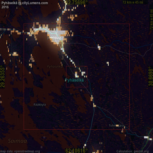
Analysis of Pyhäselkä night lights 2016
Square area 10x10 km:
 0.69%
0.69%90-99
2.96%80-89
1.28%70-79
2.57%60-69
0%50-59
0%40-49
0%30-39
0%20-29
0%10-19
0.59%0-9
91.9%Square area 50x50 km:
0.97%90-99
1.23%80-89
0.86%70-79
0.85%60-69
0.6%50-59
0.21%40-49
0.23%30-39
0.55%20-29
1.65%10-19
2.85%0-9
89.98%Clear (daylight) street map image can be seen on geolist.org.
Map coordinates:
62° 45' 25.1" North, 29° 15' 48.8" East
62° 25' 60" North, 29° 58' 0" East
62° 6' 22.2" North, 30° 40' 11.3" East
Some cities around Pyhäselkä sort by population:
• Joensuu
21.4 km =13.3 mi,  330°
330°
• Kontiolahti
36.9 km =22.9 mi,  350°
350°
• Liperi
32.8 km =20.4 mi,  289°
289°
• Kitee
38.3 km =23.8 mi,  165°
165°
• Outokumpu
58.6 km =36.4 mi,  303°
303°
• Eno
42.4 km =26.3 mi,  13°
13°
• Ilomantsi
56.2 km =34.9 mi,  61°
61°
• Kerimäki
68.1 km =42.3 mi,  211°
211°
640398 (p: 7,210)
Sources (retrieved 2019-11-25):
» Earth at Night: Flat Maps 2012, 2016