Kitee night lights from space
Night Light of Kitee (North Karelia) from space (Finland) Src. Average luminocity for 10x10km area is 10.5711% and for 50x50km: 1.3576%.
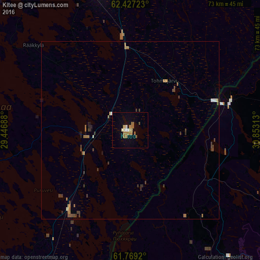
Analysis of Kitee night lights 2016
Square area 10x10 km:
 0.59%
0.59%90-99
1.28%80-89
0.99%70-79
1.38%60-69
4.94%50-59
1.09%40-49
0.4%30-39
0%20-29
0%10-19
3.16%0-9
86.17%Square area 50x50 km:
0.06%90-99
0.1%80-89
0.1%70-79
0.14%60-69
0.53%50-59
0.13%40-49
0.28%30-39
0.38%20-29
0.13%10-19
0.24%0-9
97.89%Clear (daylight) street map image can be seen on geolist.org.
Map coordinates:
62° 25' 38" North, 29° 26' 48.8" East
62° 6' 0" North, 30° 9' 0" East
61° 46' 9.1" North, 30° 51' 11.3" East
Some cities around Kitee sort by population:
• Joensuu
59.2 km =36.8 mi,  340°
340°
• Savonlinna
71.1 km =44.2 mi,  248°
248°
• Sortavala, RU
52.1 km =32.4 mi,  145°
145°
• Kontiolahti
75 km =46.6 mi,  348°
348°
• Liperi
62.9 km =39.1 mi,  319°
319°
• Lakhdenpokh’ya, RU
64.6 km =40.1 mi,  177°
177°
• Pyhäselkä
38.3 km =23.8 mi, 345°
• Kerimäki
49.9 km =31 mi, 245°
652615 (p: 9,777)
Sources (retrieved 2019-11-25):
» Earth at Night: Flat Maps 2012, 2016