Liperi night lights from space
Night Light of Liperi (North Karelia) from space (Finland) Src. Average luminocity for 10x10km area is 6.1126% and for 50x50km: 6.7498%.
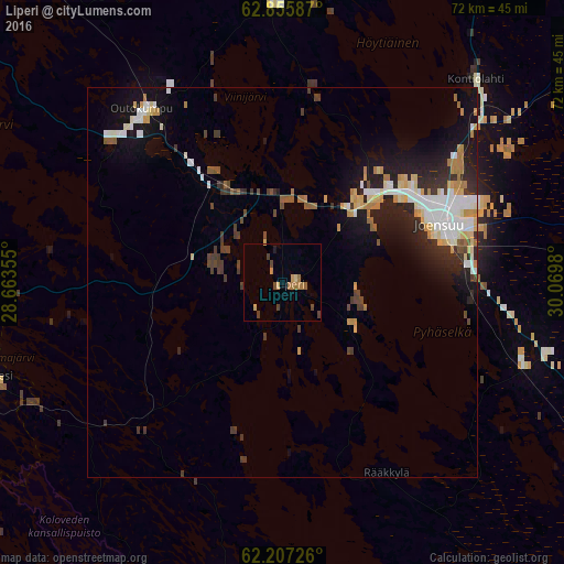
Analysis of Liperi night lights 2016
Square area 10x10 km:
 0%
0%90-99
0%80-89
0.79%70-79
1.58%60-69
2.17%50-59
0.49%40-49
2.08%30-39
0.59%20-29
0%10-19
0.4%0-9
91.9%Square area 50x50 km:
1.11%90-99
1.31%80-89
0.77%70-79
0.87%60-69
0.72%50-59
0.44%40-49
0.63%30-39
1.16%20-29
1.63%10-19
4.66%0-9
86.7%Clear (daylight) street map image can be seen on geolist.org.
Map coordinates:
62° 51' 21.1" North, 28° 39' 48.8" East
62° 31' 60" North, 29° 22' 0" East
62° 12' 26.1" North, 30° 4' 11.3" East
Some cities around Liperi sort by population:
• Joensuu
21.7 km =13.5 mi,  69°
69°
• Savonlinna
78 km =48.5 mi,  198°
198°
• Kontiolahti
35.2 km =21.9 mi,  44°
44°
• Kitee
62.9 km =39.1 mi,  139°
139°
• Outokumpu
28 km =17.4 mi,  320°
320°
• Pyhäselkä
32.8 km =20.4 mi,  109°
109°
• Eno
50.3 km =31.3 mi,  53°
53°
• Kerimäki
69.4 km =43.1 mi,  183°
183°
647851 (p: 11,386)
Sources (retrieved 2019-11-25):
» Earth at Night: Flat Maps 2012, 2016