Eno night lights from space
Night Light of Eno (North Karelia) from space (Finland) Src. Average luminocity for 10x10km area is 8.6316% and for 50x50km: 4.641%.
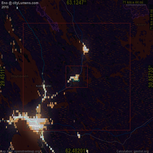
Analysis of Eno night lights 2016
Square area 10x10 km:
 0.38%
0.38%90-99
1.14%80-89
1.52%70-79
3.6%60-69
1.33%50-59
0.38%40-49
0%30-39
0%20-29
0%10-19
0.66%0-9
91%Square area 50x50 km:
0.82%90-99
1.06%80-89
0.69%70-79
0.82%60-69
0.6%50-59
0.05%40-49
0.02%30-39
0.36%20-29
1.08%10-19
2.7%0-9
91.79%Clear (daylight) street map image can be seen on geolist.org.
Map coordinates:
63° 7' 28.9" North, 29° 27' 4" East
62° 48' 18.4" North, 30° 9' 15.2" East
62° 28' 55.2" North, 30° 51' 26.5" East
Some cities around Eno sort by population:
• Joensuu
30.2 km =18.8 mi,  221°
221°
• Lieksa
57.3 km =35.6 mi,  353°
353°
• Kontiolahti
16.4 km =10.2 mi,  252°
252°
• Liperi
50.3 km =31.3 mi,  233°
233°
• Outokumpu
58.6 km =36.4 mi,  261°
261°
• Pyhäselkä
42.4 km =26.3 mi,  193°
193°
• Ilomantsi
42.3 km =26.3 mi,  110°
110°
• Juuka
65.9 km =40.9 mi,  316°
316°
660242 (p: 6,891)
Sources (retrieved 2019-11-25):
» Earth at Night: Flat Maps 2012, 2016