Nastola night lights from space
Night Light of Nastola (Päijänne Tavastia) from space (Finland) Src. Average luminocity for 10x10km area is 33.0155% and for 50x50km: 13.8482%.
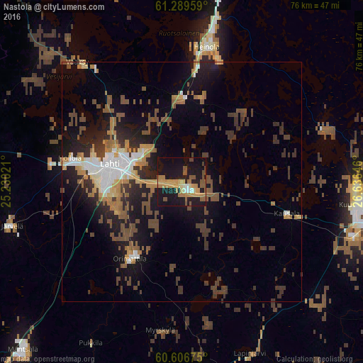
Analysis of Nastola night lights 2016
Square area 10x10 km:
 0.72%
0.72%90-99
2.58%80-89
2.79%70-79
12.19%60-69
6.51%50-59
7.33%40-49
2.89%30-39
0.1%20-29
4.65%10-19
49.9%0-9
10.33%Square area 50x50 km:
1.32%90-99
1.86%80-89
0.96%70-79
1.8%60-69
2.13%50-59
2.38%40-49
3.37%30-39
3.2%20-29
3.04%10-19
10.16%0-9
69.78%Clear (daylight) street map image can be seen on geolist.org.
Map coordinates:
61° 17' 22.5" North, 25° 13' 48.8" East
60° 57' 0" North, 25° 55' 60" East
60° 36' 24.3" North, 26° 38' 11.3" East
Some cities around Nastola sort by population:
• Lahti
15.1 km =9.4 mi,  283°
283°
• Kouvola
42.5 km =26.4 mi,  102°
102°
• Heinola
29 km =18 mi,  11°
11°
• Hollola
29.2 km =18.1 mi,  292°
292°
• Orimattila
19.5 km =12.1 mi,  214°
214°
• Elimäki
38.8 km =24.1 mi,  131°
131°
• Asikkala
37.7 km =23.4 mi,  321°
321°
• Iitti
22.7 km =14.1 mi,  105°
105°
645035 (p: 14,911)
Sources (retrieved 2019-11-25):
» Earth at Night: Flat Maps 2012, 2016