Iitti night lights from space
Night Light of Iitti (Kymenlaakso) from space (Finland) Src. Average luminocity for 10x10km area is 6.9215% and for 50x50km: 12.4222%.
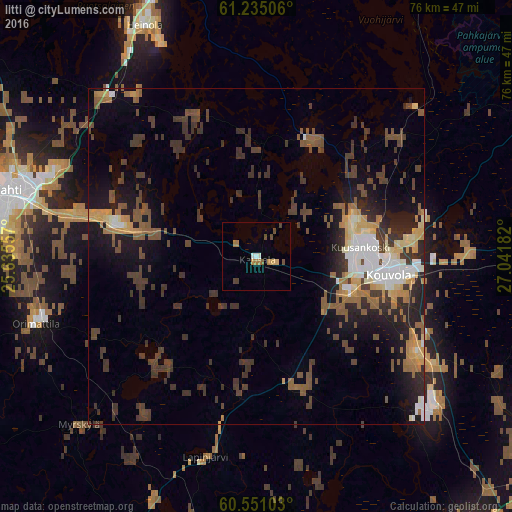
Analysis of Iitti night lights 2016
Square area 10x10 km:
 0.1%
0.1%90-99
1.14%80-89
1.24%70-79
0.62%60-69
1.96%50-59
0.41%40-49
2.48%30-39
0.31%20-29
0%10-19
0%0-9
91.74%Square area 50x50 km:
1.18%90-99
1.65%80-89
1.14%70-79
1.55%60-69
1.5%50-59
2.24%40-49
2.87%30-39
4.06%20-29
2.91%10-19
6.08%0-9
74.82%Clear (daylight) street map image can be seen on geolist.org.
Map coordinates:
61° 14' 6.2" North, 25° 38' 8.1" East
60° 53' 41.6" North, 26° 20' 19.3" East
60° 33' 3.7" North, 27° 2' 30.6" East
Some cities around Iitti sort by population:
• Lahti
37.9 km =23.5 mi,  284°
284°
• Kouvola
19.8 km =12.3 mi,  99°
99°
• Heinola
38.2 km =23.7 mi,  334°
334°
• Anjala
35.7 km =22.2 mi,  131°
131°
• Lovisa
49.1 km =30.5 mi,  187°
187°
• Nastola
22.7 km =14.1 mi,  285°
285°
• Orimattila
34.5 km =21.4 mi,  253°
253°
• Elimäki
21 km =13 mi,  160°
160°
656807 (p: 7,246)
Sources (retrieved 2019-11-25):
» Earth at Night: Flat Maps 2012, 2016