Tavernes de la Valldigna night lights from space
Night Light of Tavernes de la Valldigna (Valencia) from space (Spain) Src. Average luminocity for 10x10km area is 22.474% and for 50x50km: 16.0999%.
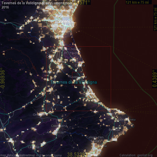
Analysis of Tavernes de la Valldigna night lights 2016
Square area 10x10 km:
 2.6%
2.6%90-99
2.6%80-89
3.73%70-79
2.76%60-69
2.27%50-59
1.62%40-49
2.6%30-39
2.44%20-29
4.22%10-19
35.88%0-9
39.29%Square area 50x50 km:
1.47%90-99
2.24%80-89
2.33%70-79
2.1%60-69
1.73%50-59
1.92%40-49
1.4%30-39
2.49%20-29
5.44%10-19
19.97%0-9
58.92%Clear (daylight) street map image can be seen on geolist.org.
Map coordinates:
39° 36' 56.6" North, 0° 58' 9.7" West
39° 4' 19" North, 0° 15' 58.4" West
38° 31' 26.3" North, 0° 26' 12.8" East
Some cities around Tavernes de la Valldigna sort by population:
• Gandia
13.7 km =8.5 mi,  148°
148°
• Alzira
16.8 km =10.4 mi,  301°
301°
• Sueca
15 km =9.3 mi,  345°
345°
• Oliva
21.2 km =13.2 mi,  143°
143°
• Algemesí
19.7 km =12.2 mi,  312°
312°
• Cullera
10.6 km =6.6 mi,  7°
7°
• Carcaixent
16.6 km =10.3 mi,  289°
289°
• Benigànim
19.8 km =12.3 mi,  226°
226°
2510743 (p: 18,195)
Sources (retrieved 2019-11-25):
» Earth at Night: Flat Maps 2012, 2016