Moralzarzal night lights from space
Night Light of Moralzarzal (Madrid) from space (Spain) Src. Average luminocity for 10x10km area is 46.9269% and for 50x50km: 22.9819%.
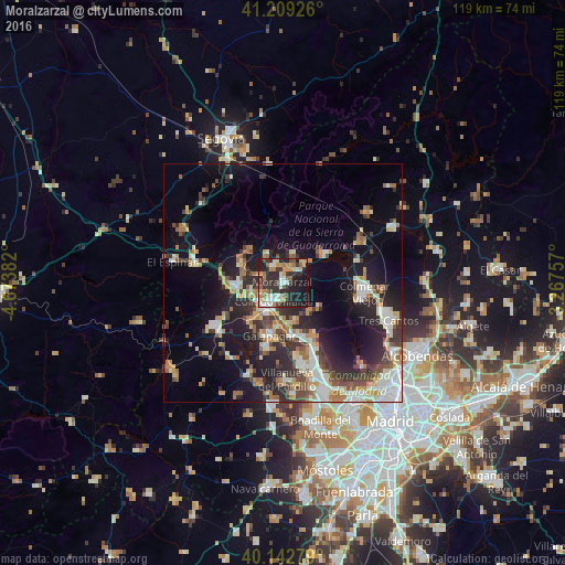
Analysis of Moralzarzal night lights 2016
Square area 10x10 km:
 5.52%
5.52%90-99
10.23%80-89
4.55%70-79
8.6%60-69
6.33%50-59
4.55%40-49
4.06%30-39
10.23%20-29
26.62%10-19
19.16%0-9
0.16%Square area 50x50 km:
3.48%90-99
4.38%80-89
2.18%70-79
2.93%60-69
3.02%50-59
2.63%40-49
3.08%30-39
3.76%20-29
7.27%10-19
14.02%0-9
53.27%Clear (daylight) street map image can be seen on geolist.org.
Map coordinates:
41° 12' 33.3" North, 4° 40' 25.8" West
40° 40' 41.4" North, 3° 58' 14.5" West
40° 8' 34" North, 3° 16' 3.3" West
Some cities around Moralzarzal sort by population:
• Collado-Villalba
5.6 km =3.5 mi,  211°
211°
• Guadarrama
10 km =6.2 mi,  266°
266°
• Alpedrete
5.1 km =3.2 mi,  244°
244°
• Hoyo de Manzanares
8.2 km =5.1 mi,  139°
139°
• Cercedilla
10.1 km =6.3 mi,  314°
314°
• Manzanares el Real
10.6 km =6.6 mi,  59°
59°
• Collado Mediano
4.7 km =2.9 mi,  290°
290°
• Boalo
6.2 km =3.9 mi,  47°
47°
3116175 (p: 11,582)
Sources (retrieved 2019-11-25):
» Earth at Night: Flat Maps 2012, 2016