Boalo night lights from space
Night Light of Boalo (Madrid) from space (Spain) Src. Average luminocity for 10x10km area is 27.1688% and for 50x50km: 21.6169%.
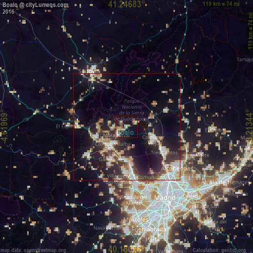
Analysis of Boalo night lights 2016
Square area 10x10 km:
 1.46%
1.46%90-99
4.71%80-89
3.25%70-79
6.66%60-69
2.44%50-59
3.57%40-49
2.11%30-39
5.36%20-29
6.17%10-19
25.49%0-9
38.8%Square area 50x50 km:
2.87%90-99
4.13%80-89
2.14%70-79
2.81%60-69
2.58%50-59
2.07%40-49
2.81%30-39
3.98%20-29
7.58%10-19
14.78%0-9
54.24%Clear (daylight) street map image can be seen on geolist.org.
Map coordinates:
41° 14' 48.6" North, 4° 37' 10.9" West
40° 42' 57.7" North, 3° 54' 59.6" West
40° 10' 51.5" North, 3° 12' 48.4" West
Some cities around Boalo sort by population:
• Collado-Villalba
11.7 km =7.3 mi,  219°
219°
• Colmenar Viejo
14.1 km =8.8 mi,  116°
116°
• Alpedrete
11.1 km =6.9 mi,  235°
235°
• Moralzarzal
6.2 km =3.9 mi,  227°
227°
• Hoyo de Manzanares
10.4 km =6.5 mi,  175°
175°
• Cercedilla
12.1 km =7.5 mi,  283°
283°
• Manzanares el Real
4.7 km =2.9 mi,  75°
75°
• Collado Mediano
9.3 km =5.8 mi,  254°
254°
3127952 (p: 5,094)
Sources (retrieved 2019-11-25):
» Earth at Night: Flat Maps 2012, 2016