Manzanares el Real night lights from space
Night Light of Manzanares el Real (Madrid) from space (Spain) Src. Average luminocity for 10x10km area is 12.9724% and for 50x50km: 22.3833%.
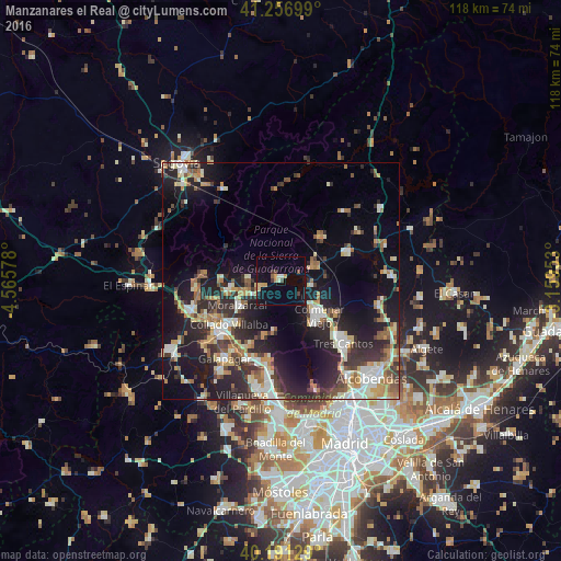
Analysis of Manzanares el Real night lights 2016
Square area 10x10 km:
 0.49%
0.49%90-99
1.46%80-89
1.14%70-79
3.25%60-69
0.16%50-59
1.3%40-49
1.46%30-39
1.79%20-29
0.65%10-19
13.31%0-9
75%Square area 50x50 km:
2.78%90-99
4.23%80-89
2.17%70-79
3.1%60-69
3.24%50-59
2.31%40-49
2.81%30-39
3.89%20-29
7.9%10-19
15.24%0-9
52.33%Clear (daylight) street map image can be seen on geolist.org.
Map coordinates:
41° 15' 25.2" North, 4° 33' 56.8" West
40° 43' 34.6" North, 3° 51' 45.5" West
40° 11' 28.6" North, 3° 9' 34.3" West
Some cities around Manzanares el Real sort by population:
• Collado-Villalba
15.7 km =9.8 mi,  229°
229°
• Colmenar Viejo
11 km =6.8 mi,  132°
132°
• Alpedrete
15.6 km =9.7 mi,  241°
241°
• Moralzarzal
10.6 km =6.6 mi, 239°
• Hoyo de Manzanares
12.1 km =7.5 mi,  198°
198°
• Collado Mediano
14 km =8.7 mi,  254°
254°
• Miraflores de la Sierra
13 km =8.1 mi,  40°
40°
• Boalo
4.7 km =2.9 mi,  255°
255°
3117503 (p: 6,231)
Sources (retrieved 2019-11-25):
» Earth at Night: Flat Maps 2012, 2016