Guadarrama night lights from space
Night Light of Guadarrama (Madrid) from space (Spain) Src. Average luminocity for 10x10km area is 37.8084% and for 50x50km: 17.2171%.
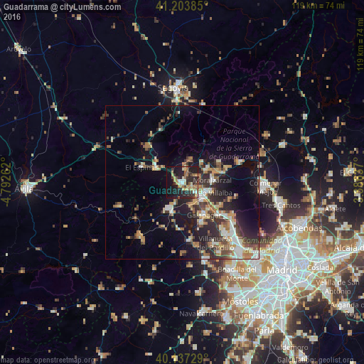
Analysis of Guadarrama night lights 2016
Square area 10x10 km:
 2.6%
2.6%90-99
5.19%80-89
5.84%70-79
5.68%60-69
8.6%50-59
3.08%40-49
4.38%30-39
4.87%20-29
22.24%10-19
33.28%0-9
4.22%Square area 50x50 km:
1.85%90-99
3.03%80-89
1.66%70-79
2.38%60-69
2.56%50-59
2.12%40-49
2.46%30-39
3.07%20-29
5.82%10-19
11.3%0-9
63.75%Clear (daylight) street map image can be seen on geolist.org.
Map coordinates:
41° 12' 13.9" North, 4° 47' 33.4" West
40° 40' 21.7" North, 4° 5' 22.2" West
40° 8' 14.2" North, 3° 23' 10.9" West
Some cities around Guadarrama sort by population:
• Collado-Villalba
8.3 km =5.2 mi,  120°
120°
• Galapagar
12.7 km =7.9 mi,  145°
145°
• San Lorenzo de El Escorial
10.3 km =6.4 mi,  208°
208°
• El Escorial
10.6 km =6.6 mi,  198°
198°
• Alpedrete
5.6 km =3.5 mi,  105°
105°
• Moralzarzal
10 km =6.2 mi,  86°
86°
• Cercedilla
8.1 km =5 mi,  20°
20°
• Collado Mediano
6.1 km =3.8 mi,  67°
67°
3121058 (p: 14,800)
Sources (retrieved 2019-11-25):
» Earth at Night: Flat Maps 2012, 2016