Cercedilla night lights from space
Night Light of Cercedilla (Madrid) from space (Spain) Src. Average luminocity for 10x10km area is 19.8977% and for 50x50km: 16.058%.
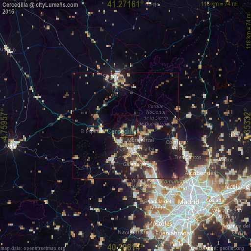
Analysis of Cercedilla night lights 2016
Square area 10x10 km:
 0%
0%90-99
2.11%80-89
1.79%70-79
1.3%60-69
6.82%50-59
3.73%40-49
1.62%30-39
2.6%20-29
8.77%10-19
25.97%0-9
45.29%Square area 50x50 km:
1.53%90-99
2.71%80-89
1.62%70-79
2.38%60-69
2.53%50-59
1.63%40-49
2%30-39
2.84%20-29
5.28%10-19
12.47%0-9
65.01%Clear (daylight) street map image can be seen on geolist.org.
Map coordinates:
41° 16' 17.8" North, 4° 45' 34.5" West
40° 44' 27.6" North, 4° 3' 23.2" West
40° 12' 22.1" North, 3° 21' 12" West
Some cities around Cercedilla sort by population:
• Collado-Villalba
12.6 km =7.8 mi,  159°
159°
• Guadarrama
8.1 km =5 mi,  200°
200°
• Alpedrete
9.5 km =5.9 mi, 163°
• Moralzarzal
10.1 km =6.3 mi,  134°
134°
• Hoyo de Manzanares
18.2 km =11.3 mi,  136°
136°
• Manzanares el Real
16.4 km =10.2 mi,  95°
95°
• Collado Mediano
6 km =3.7 mi,  151°
151°
• Boalo
12.1 km =7.5 mi, 103°
3125408 (p: 6,747)
Sources (retrieved 2019-11-25):
» Earth at Night: Flat Maps 2012, 2016