Guardamar del Segura night lights from space
Night Light of Guardamar del Segura (Valencia) from space (Spain) Src. Average luminocity for 10x10km area is 38.9075% and for 50x50km: 22.4595%.
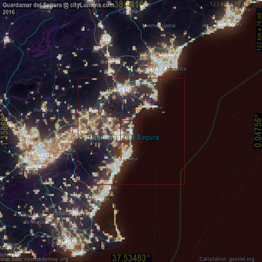
Analysis of Guardamar del Segura night lights 2016
Square area 10x10 km:
 6.17%
6.17%90-99
6.17%80-89
5.36%70-79
4.71%60-69
1.46%50-59
6.66%40-49
7.95%30-39
11.2%20-29
11.04%10-19
20.62%0-9
18.67%Square area 50x50 km:
3%90-99
3.59%80-89
2.78%70-79
2.82%60-69
2.74%50-59
2.39%40-49
3.72%30-39
4.76%20-29
9.92%10-19
15.14%0-9
49.13%Clear (daylight) street map image can be seen on geolist.org.
Map coordinates:
38° 38' 29.8" North, 1° 21' 31.3" West
38° 5' 25.1" North, 0° 39' 20" West
37° 32' 5.4" North, 0° 2' 51.2" East
Some cities around Guardamar del Segura sort by population:
• Torrevieja
12.6 km =7.8 mi,  190°
190°
• Santa Pola
13.7 km =8.5 mi,  34°
34°
• Rojales
6.1 km =3.8 mi,  267°
267°
• Almoradí
12.1 km =7.5 mi,  279°
279°
• Dolores
11.5 km =7.1 mi,  298°
298°
• San Miguel de Salinas
17 km =10.6 mi,  223°
223°
• Catral
15 km =9.3 mi, 301°
• Benejúzar
16.2 km =10.1 mi,  264°
264°
2516902 (p: 16,329)
Sources (retrieved 2019-11-25):
» Earth at Night: Flat Maps 2012, 2016