Almoradí night lights from space
Night Light of Almoradí (Valencia) from space (Spain) Src. Average luminocity for 10x10km area is 53.763% and for 50x50km: 28.422%.
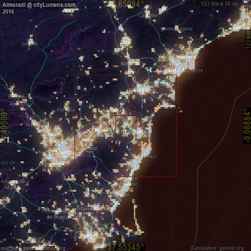
Analysis of Almoradí night lights 2016
Square area 10x10 km:
 2.44%
2.44%90-99
7.14%80-89
8.6%70-79
10.88%60-69
9.42%50-59
10.23%40-49
16.23%30-39
18.18%20-29
16.23%10-19
0.65%0-9
0%Square area 50x50 km:
3.27%90-99
4.35%80-89
3.64%70-79
3.78%60-69
4.22%50-59
3.56%40-49
4.54%30-39
5.64%20-29
12.2%10-19
17.75%0-9
37.04%Clear (daylight) street map image can be seen on geolist.org.
Map coordinates:
38° 39' 35.8" North, 1° 29' 42.3" West
38° 6' 31.6" North, 0° 47' 31.1" West
37° 33' 12.4" North, 0° 5' 19.8" West
Some cities around Almoradí sort by population:
• Rojales
6.3 km =3.9 mi,  111°
111°
• Callosa de Segura
7.8 km =4.8 mi,  283°
283°
• Albatera
10.4 km =6.5 mi,  318°
318°
• Dolores
3.9 km =2.4 mi,  27°
27°
• Redován
10.3 km =6.4 mi,  274°
274°
• Cox
9.1 km =5.7 mi,  293°
293°
• Catral
5.8 km =3.6 mi,  351°
351°
• Benejúzar
5.4 km =3.4 mi,  229°
229°
2521855 (p: 19,147)
Sources (retrieved 2019-11-25):
» Earth at Night: Flat Maps 2012, 2016