Catral night lights from space
Night Light of Catral (Valencia) from space (Spain) Src. Average luminocity for 10x10km area is 41.6548% and for 50x50km: 29.6359%.
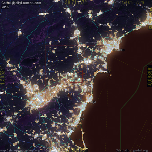
Analysis of Catral night lights 2016
Square area 10x10 km:
 3.06%
3.06%90-99
3.91%80-89
4.59%70-79
6.63%60-69
3.91%50-59
9.69%40-49
13.27%30-39
12.93%20-29
15.65%10-19
26.36%0-9
0%Square area 50x50 km:
3.22%90-99
4.37%80-89
4%70-79
4.03%60-69
4.7%50-59
4.01%40-49
4.76%30-39
5.8%20-29
11.89%10-19
18.89%0-9
34.34%Clear (daylight) street map image can be seen on geolist.org.
Map coordinates:
38° 42' 40.9" North, 1° 30' 18.8" West
38° 9' 38.2" North, 0° 48' 7.5" West
37° 36' 20.4" North, 0° 5' 56.3" West
Some cities around Catral sort by population:
• Crevillente
10 km =6.2 mi,  356°
356°
• Rojales
10.5 km =6.5 mi,  140°
140°
• Almoradí
5.8 km =3.6 mi,  171°
171°
• Callosa de Segura
7.7 km =4.8 mi,  239°
239°
• Albatera
6.3 km =3.9 mi,  288°
288°
• Dolores
3.6 km =2.2 mi,  129°
129°
• Cox
7.7 km =4.8 mi,  254°
254°
• Benejúzar
9.8 km =6.1 mi,  199°
199°
2519688 (p: 6,147)
Sources (retrieved 2019-11-25):
» Earth at Night: Flat Maps 2012, 2016