Fisterra night lights from space
Night Light of Fisterra (Galicia) from space (Spain) Src. Average luminocity for 10x10km area is 2.454% and for 50x50km: 2.3903%.
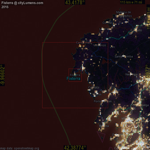
Analysis of Fisterra night lights 2016
Square area 10x10 km:
100  0%
0%
90-99 0%
80-89 0%
70-79 0.63%
60-69 0%
50-59 0%
40-49 1.75%
30-39 0.48%
20-29 1.59%
10-19 0.63%
0-9 94.92%
0%90-99
0%80-89
0%70-79
0.63%60-69
0%50-59
0%40-49
1.75%30-39
0.48%20-29
1.59%10-19
0.63%0-9
94.92%Square area 50x50 km:
100 0.07%
90-99 0.37%
80-89 0.2%
70-79 0.21%
60-69 0.27%
50-59 0.27%
40-49 0.54%
30-39 0.56%
20-29 0.81%
10-19 0.49%
0-9 96.22%
0.07%90-99
0.37%80-89
0.2%70-79
0.21%60-69
0.27%50-59
0.27%40-49
0.54%30-39
0.56%20-29
0.81%10-19
0.49%0-9
96.22%Clear (daylight) street map image can be seen on geolist.org.
Map coordinates:
43° 25' 4.1" North, 9° 57' 57.7" West
42° 54' 17.7" North, 9° 15' 46.4" West
42° 23' 15.9" North, 8° 33' 35.2" West
Some cities around Fisterra sort by population:
• Muros
21.9 km =13.6 mi,  130°
130°
• Porto do Son
29 km =18 mi, 133°
• Outes
29.8 km =18.5 mi,  99°
99°
• Cee
8.2 km =5.1 mi,  47°
47°
• Camariñas
26 km =16.2 mi,  14°
14°
• Mazaricos
24 km =14.9 mi,  80°
80°
• Mugia
22.5 km =14 mi, 9°
• Carnota
16.8 km =10.4 mi,  122°
122°
3122426 (p: 5,005)
Sources (retrieved 2019-11-25):
» Earth at Night: Flat Maps 2012, 2016