Cee night lights from space
Night Light of Cee (Galicia) from space (Spain) Src. Average luminocity for 10x10km area is 9.5476% and for 50x50km: 3.2108%.
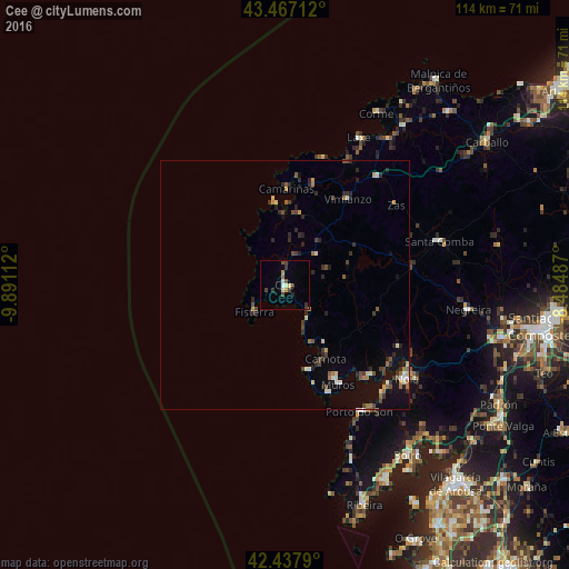
Analysis of Cee night lights 2016
Square area 10x10 km:
100  0.48%
0.48%
90-99 1.9%
80-89 0.79%
70-79 1.27%
60-69 0.79%
50-59 1.11%
40-49 2.7%
30-39 2.22%
20-29 1.27%
10-19 0%
0-9 87.46%
0.48%90-99
1.9%80-89
0.79%70-79
1.27%60-69
0.79%50-59
1.11%40-49
2.7%30-39
2.22%20-29
1.27%10-19
0%0-9
87.46%Square area 50x50 km:
100 0.09%
90-99 0.47%
80-89 0.28%
70-79 0.3%
60-69 0.48%
50-59 0.41%
40-49 0.61%
30-39 0.65%
20-29 1.14%
10-19 1.44%
0-9 94.12%
0.09%90-99
0.47%80-89
0.28%70-79
0.3%60-69
0.48%50-59
0.41%40-49
0.61%30-39
0.65%20-29
1.14%10-19
1.44%0-9
94.12%Clear (daylight) street map image can be seen on geolist.org.
Map coordinates:
43° 28' 1.6" North, 9° 53' 28" West
42° 57' 16.8" North, 9° 11' 16.8" West
42° 26' 16.4" North, 8° 29' 5.5" West
Some cities around Cee sort by population:
• Muros
22.4 km =13.9 mi,  152°
152°
• Porto do Son
29.6 km =18.4 mi, 149°
• Outes
25.5 km =15.8 mi,  113°
113°
• Camariñas
19.6 km =12.2 mi,  1°
1°
• Mazaricos
17.7 km =11 mi,  95°
95°
• Mugia
16.8 km =10.4 mi,  351°
351°
• Carnota
16.7 km =10.4 mi, 151°
• Fisterra
8.2 km =5.1 mi,  227°
227°
3125526 (p: 7,381)
Sources (retrieved 2019-11-25):
» Earth at Night: Flat Maps 2012, 2016