Esplugues de Llobregat night lights from space
Night Light of Esplugues de Llobregat (Catalonia) from space (Spain) Src. Average luminocity for 10x10km area is 91% and for 50x50km: 42.2222%.

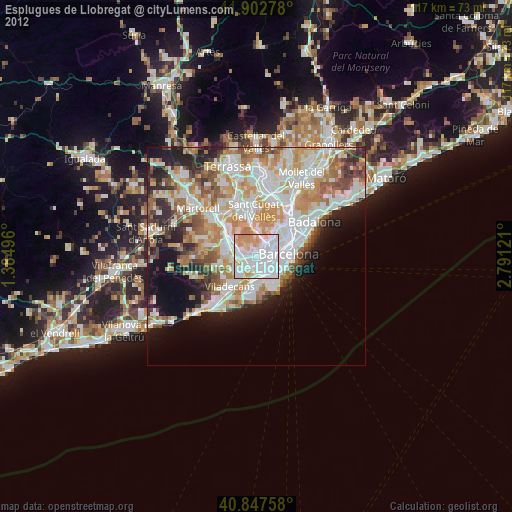
Analysis of Esplugues de Llobregat night lights 2016
Square area 10x10 km:
 44.56%
90-99
27.72%80-89
2.55%70-79
11.9%60-69
10.03%50-59
3.23%40-49
0%30-39
0%20-29
0%10-19
0%0-9
0%Square area 50x50 km:
11.31%90-99
9.9%80-89
4.02%70-79
5.13%60-69
7.24%50-59
5.48%40-49
3.43%30-39
3.78%20-29
7.7%10-19
8.74%0-9
33.25%Clear (daylight) street map image can be seen on geolist.org.
Map coordinates:
41° 54' 10" North, 1° 23' 5.9" East
41° 22' 38.4" North, 2° 5' 17.1" East
40° 50' 51.3" North, 2° 47' 28.4" East
Some cities around Esplugues de Llobregat sort by population:
• L'Hospitalet de Llobregat
2.2 km =1.4 mi,  152°
152°
• Cornellà de Llobregat
3.1 km =1.9 mi,  187°
187°
• Sant Feliu de Llobregat
3.2 km =2 mi,  281°
281°
• Sant Joan Despí
2.8 km =1.7 mi,  246°
246°
• Sants - Badal
3.3 km =2.1 mi,  95°
95°
• la Maternitat i Sant Ramon
2.5 km =1.6 mi,  79°
79°
• Sant Just Desvern
1.9 km =1.2 mi,  293°
293°
• Pedralbes
2.4 km =1.5 mi,  51°
51°
3122826 (p: 46,862)
Sources (retrieved 2019-11-25):
» Earth at Night: Flat Maps 2012, 2016