Sant Feliu de Llobregat night lights from space
Night Light of Sant Feliu de Llobregat (Catalonia) from space (Spain) Src. Average luminocity for 10x10km area is 85.6412% and for 50x50km: 43.8219%.

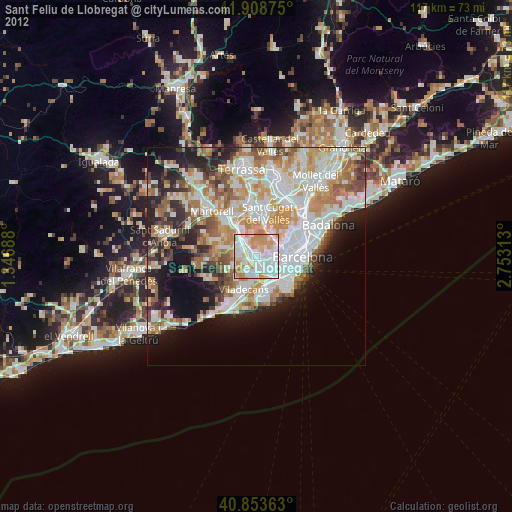
Analysis of Sant Feliu de Llobregat night lights 2016
Square area 10x10 km:
 29.93%
90-99
25.17%80-89
6.29%70-79
14.29%60-69
18.2%50-59
6.12%40-49
0%30-39
0%20-29
0%10-19
0%0-9
0%Square area 50x50 km:
11.3%90-99
10.04%80-89
4.38%70-79
5.33%60-69
7.35%50-59
6.03%40-49
3.69%30-39
4.03%20-29
8.64%10-19
10.31%0-9
28.89%Clear (daylight) street map image can be seen on geolist.org.
Map coordinates:
41° 54' 31.5" North, 1° 20' 48.8" East
41° 22' 60" North, 2° 3' 0" East
40° 51' 13.1" North, 2° 45' 11.3" East
Some cities around Sant Feliu de Llobregat sort by population:
• L'Hospitalet de Llobregat
5 km =3.1 mi,  122°
122°
• Cornellà de Llobregat
4.6 km =2.9 mi,  143°
143°
• Esplugues de Llobregat
3.2 km =2 mi,  101°
101°
• Sarrià
5.9 km =3.7 mi,  68°
68°
• Molins de Rei
4.6 km =2.9 mi,  323°
323°
• la Maternitat i Sant Ramon
5.6 km =3.5 mi,  92°
92°
• Pedralbes
5.1 km =3.2 mi,  81°
81°
• Santa Coloma de Cervelló
3.5 km =2.2 mi,  239°
239°
3110642 (p: 42,919)
Sources (retrieved 2019-11-25):
» Earth at Night: Flat Maps 2012, 2016