Castellbisbal night lights from space
Night Light of Castellbisbal (Catalonia) from space (Spain) Src. Average luminocity for 10x10km area is 75.6769% and for 50x50km: 48.7972%.
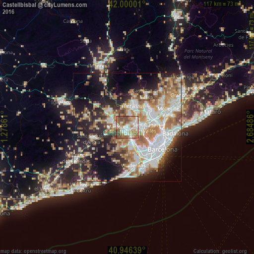
Analysis of Castellbisbal night lights 2016
Square area 10x10 km:
 17.18%
90-99
19.9%80-89
8.67%70-79
7.48%60-69
23.81%50-59
10.88%40-49
9.52%30-39
2.55%20-29
0%10-19
0%0-9
0%Square area 50x50 km:
11.36%90-99
10.61%80-89
5.13%70-79
6.09%60-69
8.75%50-59
6.79%40-49
4.21%30-39
4.58%20-29
11.29%10-19
15.37%0-9
15.82%Clear (daylight) street map image can be seen on geolist.org.
Map coordinates:
42° 0' 0" North, 1° 16' 43" East
41° 28' 31.2" North, 1° 58' 54.3" East
40° 56' 47" North, 2° 41' 5.5" East
Some cities around Castellbisbal sort by population:
• Sant Cugat del Vallès
8.7 km =5.4 mi,  93°
93°
• Rubí
4.7 km =2.9 mi,  66°
66°
• Martorell
4.3 km =2.7 mi,  268°
268°
• Sant Andreu de la Barca
3.3 km =2.1 mi,  194°
194°
• Molins de Rei
7.1 km =4.4 mi,  155°
155°
• Corbera de Llobregat
8.3 km =5.2 mi,  218°
218°
• Abrera
8.2 km =5.1 mi,  304°
304°
• Pallejà
5.8 km =3.6 mi,  169°
169°
3125904 (p: 11,977)
Sources (retrieved 2019-11-25):
» Earth at Night: Flat Maps 2012, 2016