Martorell night lights from space
Night Light of Martorell (Catalonia) from space (Spain) Src. Average luminocity for 10x10km area is 69.4422% and for 50x50km: 46.9486%.
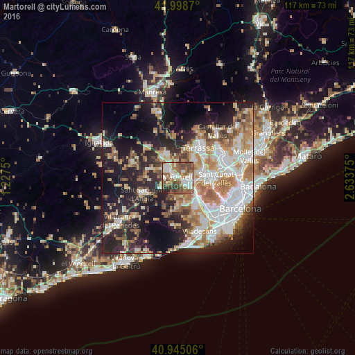

Analysis of Martorell night lights 2016
Square area 10x10 km:
 16.33%
90-99
17.18%80-89
5.1%70-79
3.57%60-69
16.84%50-59
18.54%40-49
12.07%30-39
6.97%20-29
3.4%10-19
0%0-9
0%Square area 50x50 km:
10.68%90-99
9.96%80-89
4.96%70-79
5.87%60-69
8.26%50-59
6.32%40-49
3.63%30-39
4.73%20-29
12.4%10-19
17.16%0-9
16.04%Clear (daylight) street map image can be seen on geolist.org.
Map coordinates:
41° 59' 55.3" North, 1° 13' 39" East
41° 28' 26.5" North, 1° 55' 50.2" East
40° 56' 42.2" North, 2° 38' 1.5" East
Some cities around Martorell sort by population:
• Sant Andreu de la Barca
4.6 km =2.9 mi,  131°
131°
• Olesa de Montserrat
8.3 km =5.2 mi,  338°
338°
• Esparreguera
8.7 km =5.4 mi,  324°
324°
• Corbera de Llobregat
6.4 km =4 mi,  188°
188°
• Castellbisbal
4.3 km =2.7 mi,  88°
88°
• Abrera
5.4 km =3.4 mi,  332°
332°
• Pallejà
7.7 km =4.8 mi,  136°
136°
• Gelida
7 km =4.3 mi,  229°
229°
3117331 (p: 26,681)
Sources (retrieved 2019-11-25):
» Earth at Night: Flat Maps 2012, 2016