Pallejà night lights from space
Night Light of Pallejà (Catalonia) from space (Spain) Src. Average luminocity for 10x10km area is 79.2126% and for 50x50km: 48.3605%.
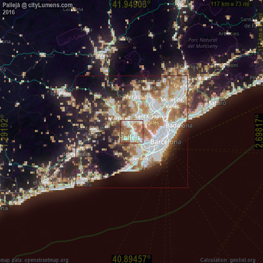
Analysis of Pallejà night lights 2016
Square area 10x10 km:
 19.05%
90-99
19.73%80-89
9.35%70-79
9.69%60-69
29.76%50-59
11.22%40-49
0.85%30-39
0.34%20-29
0%10-19
0%0-9
0%Square area 50x50 km:
11.67%90-99
10.79%80-89
5%70-79
5.89%60-69
8.57%50-59
6.63%40-49
4%30-39
4.41%20-29
10.7%10-19
14.2%0-9
18.13%Clear (daylight) street map image can be seen on geolist.org.
Map coordinates:
41° 56' 56.5" North, 1° 17' 30.9" East
41° 25' 26.2" North, 1° 59' 42.2" East
40° 53' 40.5" North, 2° 41' 53.4" East
Some cities around Pallejà sort by population:
• Sant Feliu de Llobregat
6.4 km =4 mi,  134°
134°
• Sant Vicenç dels Horts
3.6 km =2.2 mi,  163°
163°
• Sant Andreu de la Barca
3.2 km =2 mi,  322°
322°
• Molins de Rei
2 km =1.2 mi,  114°
114°
• Corbera de Llobregat
6.3 km =3.9 mi,  263°
263°
• Castellbisbal
5.8 km =3.6 mi,  349°
349°
• Cervelló
4.3 km =2.7 mi,  223°
223°
• Santa Coloma de Cervelló
6.5 km =4 mi,  165°
165°
3114516 (p: 11,134)
Sources (retrieved 2019-11-25):
» Earth at Night: Flat Maps 2012, 2016