Corbera de Llobregat night lights from space
Night Light of Corbera de Llobregat (Catalonia) from space (Spain) Src. Average luminocity for 10x10km area is 52.4643% and for 50x50km: 47.1255%.
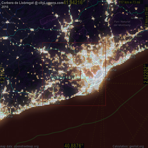
Analysis of Corbera de Llobregat night lights 2016
Square area 10x10 km:
 4.08%
4.08%90-99
6.29%80-89
4.59%70-79
5.61%60-69
18.2%50-59
18.54%40-49
8.67%30-39
11.39%20-29
14.63%10-19
7.99%0-9
0%Square area 50x50 km:
10.9%90-99
10.22%80-89
4.85%70-79
5.74%60-69
8.18%50-59
6.24%40-49
3.49%30-39
4.83%20-29
12.77%10-19
16.62%0-9
16.15%Clear (daylight) street map image can be seen on geolist.org.
Map coordinates:
41° 56' 31.8" North, 1° 12' 59.7" East
41° 25' 1.3" North, 1° 55' 10.9" East
40° 53' 15.4" North, 2° 37' 22.2" East
Some cities around Corbera de Llobregat sort by population:
• Sant Vicenç dels Horts
7.7 km =4.8 mi,  110°
110°
• Martorell
6.4 km =4 mi,  8°
8°
• Sant Andreu de la Barca
5.5 km =3.4 mi,  52°
52°
• Molins de Rei
8.1 km =5 mi,  90°
90°
• Vallirana
3.5 km =2.2 mi,  162°
162°
• Pallejà
6.3 km =3.9 mi,  83°
83°
• Cervelló
4 km =2.5 mi,  125°
125°
• Gelida
4.8 km =3 mi,  292°
292°
3124628 (p: 13,843)
Sources (retrieved 2019-11-25):
» Earth at Night: Flat Maps 2012, 2016